Bureau of Meteorology, New South Wales(@BOM_NSW) 's Twitter Profile Photo

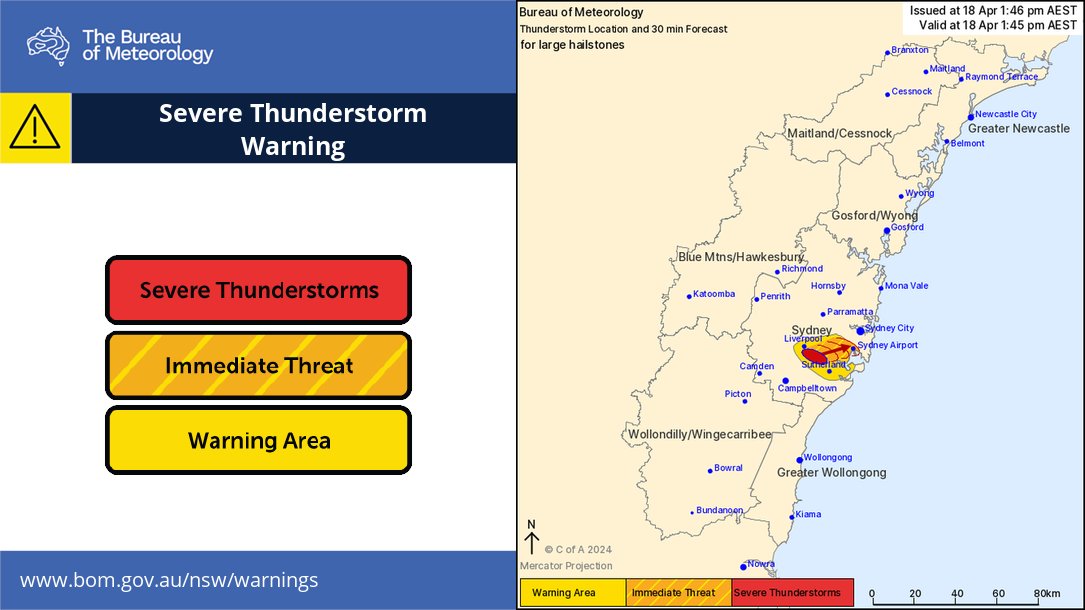
⚠️⛈️Detailed Severe Thunderstorm warning issued for areas SW of Sydney. A storm likely to produce large hailstones is located near Holsworthy. It is forecast to affect Hurstville, Padstow by 2:00 pm & Sydney Airport, Bankstown, Canterbury by 2:15 pm. bom.gov.au/products/IDN21…

⚠️⛈️Detailed Severe Thunderstorm warning issued for areas SW of Sydney. A storm likely to produce large hailstones is located near Holsworthy. It is forecast to affect Hurstville, Padstow by 2:00 pm & Sydney Airport, Bankstown, Canterbury by 2:15 pm. bom.gov.au/products/IDN21…
account_circle
Bureau of Meteorology, New South Wales(@BOM_NSW) 's Twitter Profile Photo

Severe thunderstorm warning issued for parts of the central coast and adjacent ranges, as well as the Mid North Coast about Kempsey. Risks of large, possibly giant hailstones, heavy rain and damaging winds. For up to date warnings: bom.gov.au/nsw/warnings/.

Severe thunderstorm warning issued for parts of the central coast and adjacent ranges, as well as the Mid North Coast about Kempsey. Risks of large, possibly giant hailstones, heavy rain and damaging winds. For up to date warnings: bom.gov.au/nsw/warnings/.
account_circle
Bureau of Meteorology, New South Wales(@BOM_NSW) 's Twitter Profile Photo

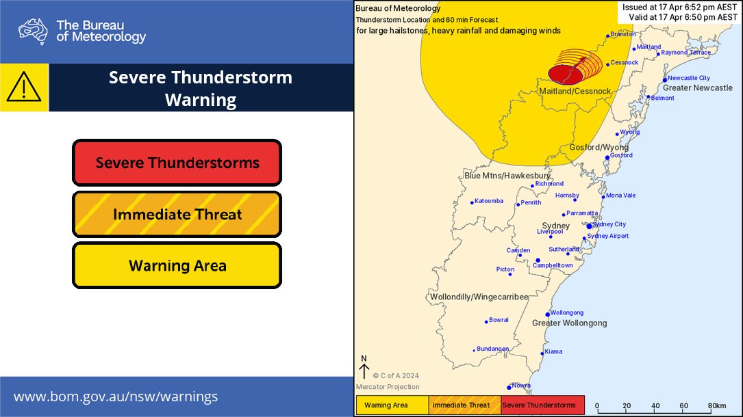
⚠️⛈️Severe thunderstorm update: severe thunderstorms ongoing west of Cessnock. Details and updates: bom.gov.au/nsw/warnings/

⚠️⛈️Severe thunderstorm #warning update: severe thunderstorms ongoing west of Cessnock. Details and updates: bom.gov.au/nsw/warnings/
account_circle
Bureau of Meteorology, New South Wales(@BOM_NSW) 's Twitter Profile Photo

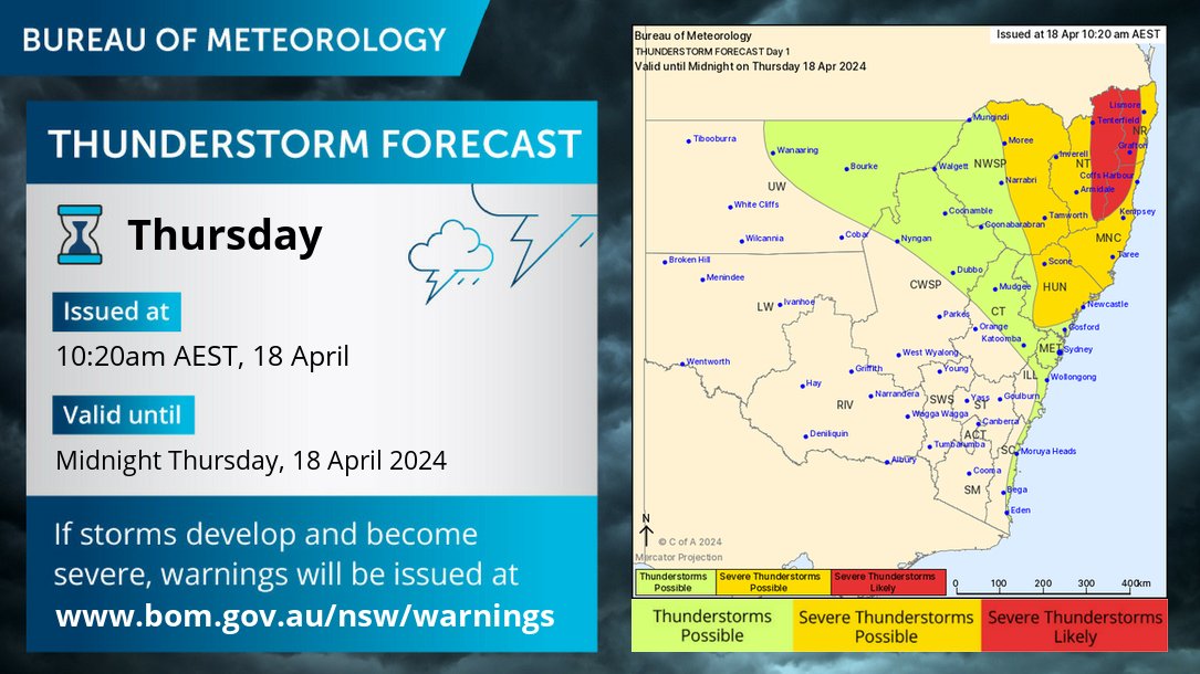
⛈️Thursday's forecast: severe thunderstorms with heavy rainfall, large hail, damaging wind gusts are possible in the northeast, and are likely in the far northeast. Thunderstorms are possible over the northern inland and coast. Today's warnings: bom.gov.au/nsw/warnings/

⛈️Thursday's forecast: severe thunderstorms with heavy rainfall, large hail, damaging wind gusts are possible in the northeast, and are likely in the far northeast. Thunderstorms are possible over the northern inland and coast. Today's warnings: bom.gov.au/nsw/warnings/
account_circle
Bureau of Meteorology, New South Wales(@BOM_NSW) 's Twitter Profile Photo

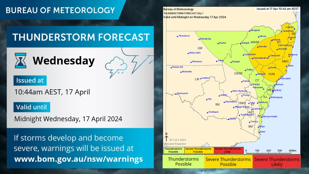
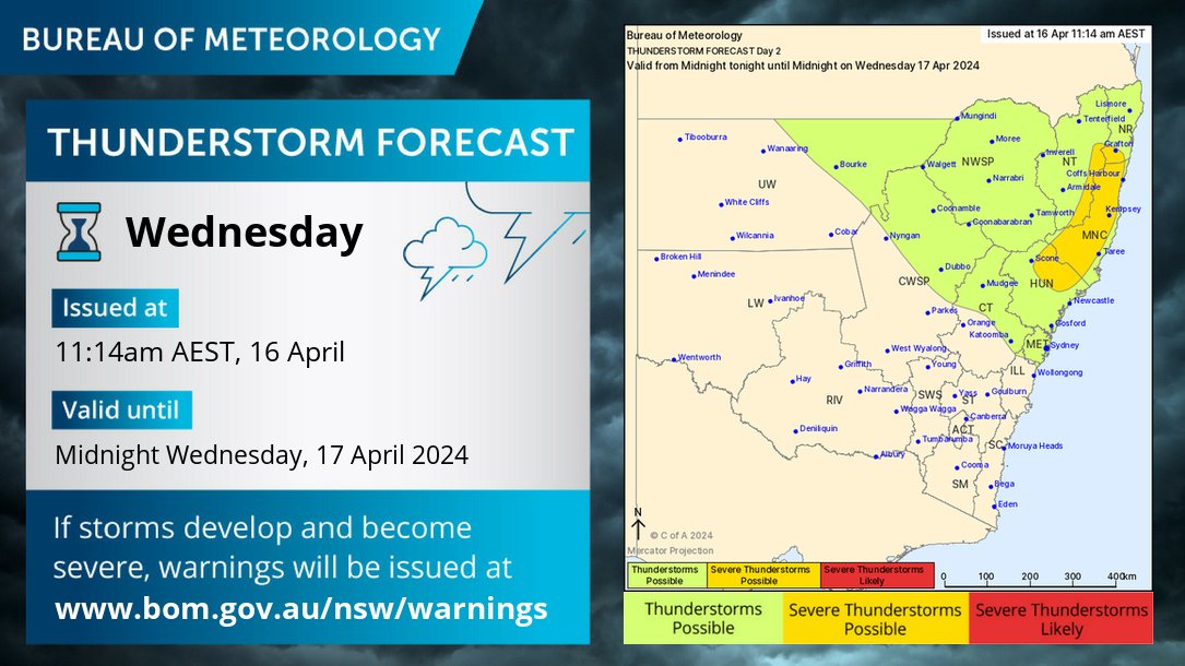
⛈️Wednesday's forecast: severe thunderstorms with heavy rainfall and large hail are possible in the northeast. Thunderstorms are possible across much of the northern inland and the coast. Warnings if needed: bom.gov.au/nsw/warnings/

⛈️Wednesday's forecast: severe thunderstorms with heavy rainfall and large hail are possible in the northeast. Thunderstorms are possible across much of the northern inland and the coast. Warnings if needed: bom.gov.au/nsw/warnings/
account_circle
Bureau of Meteorology, New South Wales(@BOM_NSW) 's Twitter Profile Photo

⚠️⛈️Severe thunderstorm has been cancelled, as thunderstorms are weakening and moving offshore. The situation will continue to be monitored. Details and updates: bom.gov.au/nsw/warnings/

⚠️⛈️Severe thunderstorm #warning has been cancelled, as thunderstorms are weakening and moving offshore. The situation will continue to be monitored. Details and updates: bom.gov.au/nsw/warnings/
account_circle
Bureau of Meteorology, New South Wales(@BOM_NSW) 's Twitter Profile Photo

🌾 NORTHERN grain growers: check the climate outlook for your region 👉🏼 youtube.com/watch?v=KPR0Z7…

Find more climate outlooks in our Playlist.

GRDC North GRDC Agricultural Innovation Australia Ltd riClimateOutlooks

🌾 NORTHERN grain growers: check the climate outlook for your region 👉🏼  youtube.com/watch?v=KPR0Z7… 

Find more climate outlooks in our #Ag Playlist. 
 
@GRDCNorth @theGRDC @AgInnovationAus #AgriClimateOutlooks #agchatoz
account_circle
Bureau of Meteorology, New South Wales(@BOM_NSW) 's Twitter Profile Photo

⛈️Storm Forecast for today 18/4. Severe storms are possible for the northeast quarter of NSW today, including the Hunter. Severe storms are likely in the far northeast & adjacent ranges. Heavy rainfall, damaging winds & large hailstones possible with severe storms.

⛈️Storm Forecast for today 18/4. Severe storms are possible for the northeast quarter of NSW today, including the Hunter. Severe storms are likely in the far northeast & adjacent ranges. Heavy rainfall, damaging winds & large hailstones possible with severe storms.
account_circle
Bureau of Meteorology, New South Wales(@BOM_NSW) 's Twitter Profile Photo

⛈️Wednesday's forecast: severe thunderstorms with heavy rainfall and large hail are possible in the northeast. Thunderstorms are possible in the north and over the Sydney metropolitan area. Today's warnings: bom.gov.au/nsw/warnings/

⛈️Wednesday's forecast: severe thunderstorms with heavy rainfall and large hail are possible in the northeast. Thunderstorms are possible in the north and over the Sydney metropolitan area. Today's warnings: bom.gov.au/nsw/warnings/
account_circle
Bureau of Meteorology, New South Wales(@BOM_NSW) 's Twitter Profile Photo

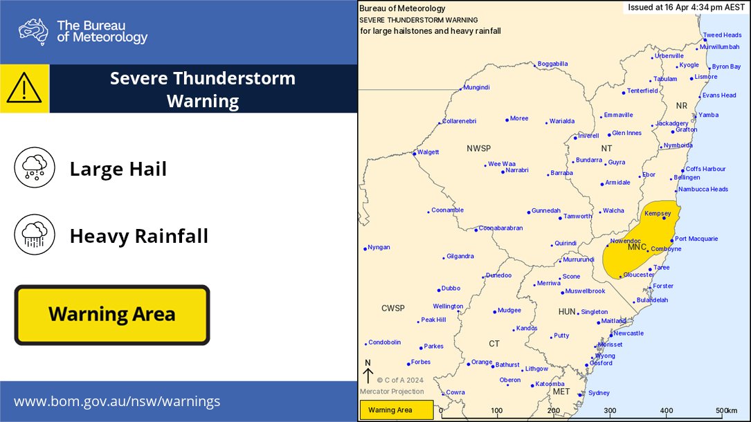
Severe Thunderstorm Warning has been updated. Now covering the area between and . Risk of heavy falls and large hail. Latest warning bom.gov.au/products/IDN21…

Severe Thunderstorm Warning has been updated. Now covering the area between #Kempsey and #Gloucester. Risk of heavy falls and large hail. Latest warning bom.gov.au/products/IDN21…
account_circle
Stephen Males(@StephenMales) 's Twitter Profile Photo

Who does Bureau of Meteorology, New South Wales only send out warnings an hour after a storm with hail has developed. For 45 mins, it went thru Camden, Campbelltown, Ingleburn, Casula, Wattle Grove and then the warning was issued. What triggers the storm warning?

account_circle
Bureau of Meteorology, New South Wales(@BOM_NSW) 's Twitter Profile Photo

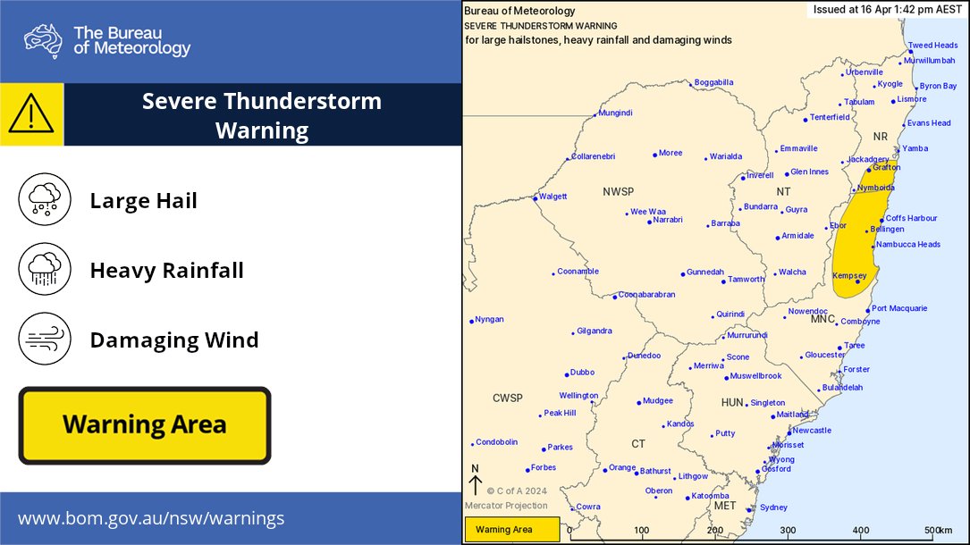
Severe Thunderstorm Warning is current for areas between and . Localised heavy rain, large hail, and damaging winds are all concerns. Latest warning bom.gov.au/products/IDN21…

Severe Thunderstorm Warning is current for areas between #Kempsey and #Grafton. Localised heavy rain, large hail, and damaging winds are all concerns. Latest warning bom.gov.au/products/IDN21…
account_circle
Bureau of Meteorology, New South Wales(@BOM_NSW) 's Twitter Profile Photo

Severe Thunderstorm Warning issued. Risk areas include the Blue Mountains, Hawkesbury, Maitland/Cessnock, Gosford/Wyong and Sydney areas. Severe cells are active and have risks of heavy rainfall, large hailstones and damaging winds. For warning details ow.ly/YMPG50RhPeV

Severe Thunderstorm Warning issued. Risk areas include the Blue Mountains, Hawkesbury, Maitland/Cessnock, Gosford/Wyong and Sydney areas. Severe cells are active and have risks of heavy rainfall, large hailstones and damaging winds. For warning details ow.ly/YMPG50RhPeV
account_circle
Bureau of Meteorology, New South Wales(@BOM_NSW) 's Twitter Profile Photo

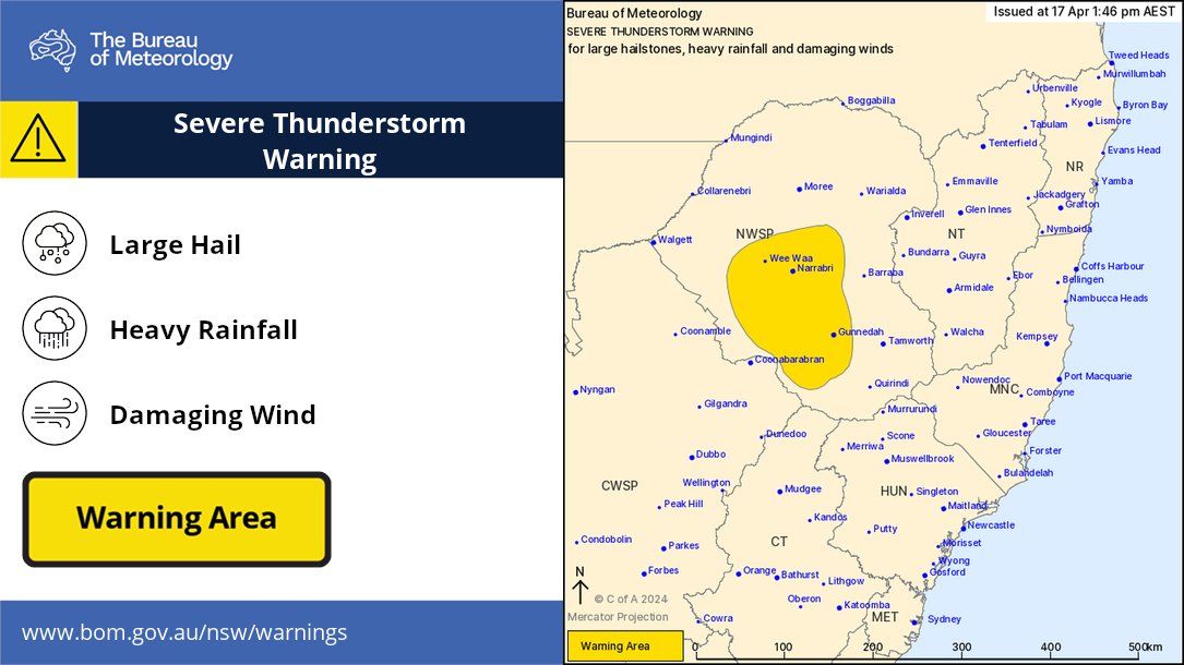
A Severe Thunderstorm Warning for LARGE HAILSTONES, HEAVY RAINFALL and DAMAGING WINDS
has been issued for parts of the North West Slopes and Plains Forecast District. Monitor the storms on radar bom.gov.au/australia/rada…

A Severe Thunderstorm Warning for LARGE HAILSTONES, HEAVY RAINFALL and DAMAGING WINDS
has been issued for parts of the North West Slopes and Plains Forecast District. Monitor the storms on radar bom.gov.au/australia/rada…
account_circle