Ed Wilson(@EdWilsonWX13HD) 's Twitter Profileg
Ed Wilson

@EdWilsonWX13HD

Meteorologist @WHOWeather @WHOHD. Married. 2 Children. Love Iowa Weather. Views are my own. Instagram: https://t.co/ViUeO5t1Ur

ID:296882238

linkhttps://www.facebook.com/edwilsonweather calendar_today11-05-2011 15:14:55

50,5K Tweets

15,9K Followers

1,6K Following

Michael Mackie(@M2Esq) 's Twitter Profile Photo

Did y'all know that today and tomorrow are Public Media Giving Days? 'Tis true! And it's your opportunity to give back to Kansas City PBS and share what public media adds to your life.

Want to make a donation and help support GetLost! on Kansas City PBS? Visit Kansascitypbs.org.

account_circle
Ed Wilson(@EdWilsonWX13HD) 's Twitter Profile Photo

The Iowa Cubs were able to fit in a double header today. Tonight the grounds crew were able to get the infield covered before the rain started this evening. Heavier rainfall is expected again tomorrow, but severe weather is not expected. WHO 13 Weather

account_circle
Ed Wilson(@EdWilsonWX13HD) 's Twitter Profile Photo

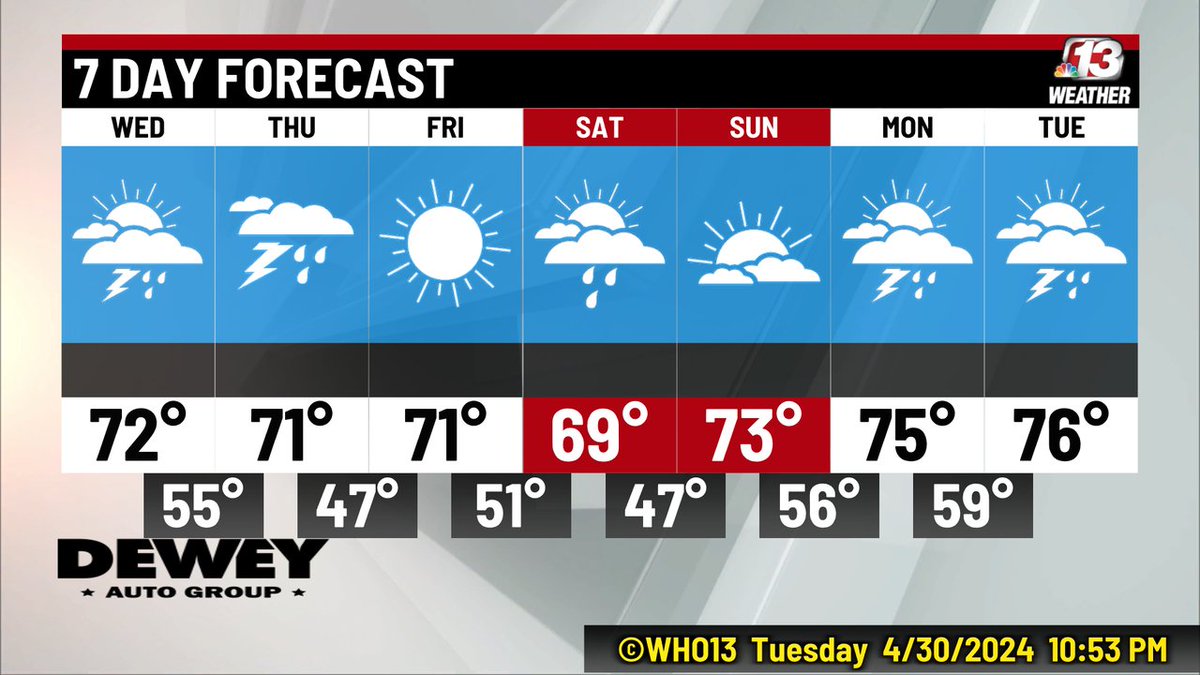
The WHO13 Seven Day has more rain and thunderstorms than dry days. Thursday has another chance for strong-to-severe storms.

The WHO13 Seven Day has more rain and thunderstorms than dry days. Thursday has another chance for strong-to-severe storms.
account_circle
Ed Wilson(@EdWilsonWX13HD) 's Twitter Profile Photo

Update on the Severe Thunderstorm Warning for Appanoose, Lucas, Monroe and Wayne Counties....The storm will be near Melrose at 7:24, Moravia at 7:45, Blakesburg at 8:01.

Update on the Severe Thunderstorm Warning for Appanoose, Lucas, Monroe and Wayne Counties....The storm will be near Melrose at 7:24, Moravia at 7:45, Blakesburg at 8:01.
account_circle
Ed Wilson(@EdWilsonWX13HD) 's Twitter Profile Photo

A Severe Severe T-Storm Warning has been issued for Appanoose, Lucas, Monroe and Wayne Counties in southern Iowa until 8 PM. This storm has the potential for large hail and damaging wind. It is moving the east at 35 MPH.

A Severe Severe T-Storm Warning has been issued for Appanoose, Lucas, Monroe and Wayne Counties in southern Iowa until 8 PM. This storm has the potential for large hail and damaging wind. It is moving the east at 35 MPH.
account_circle
Ed Wilson(@EdWilsonWX13HD) 's Twitter Profile Photo

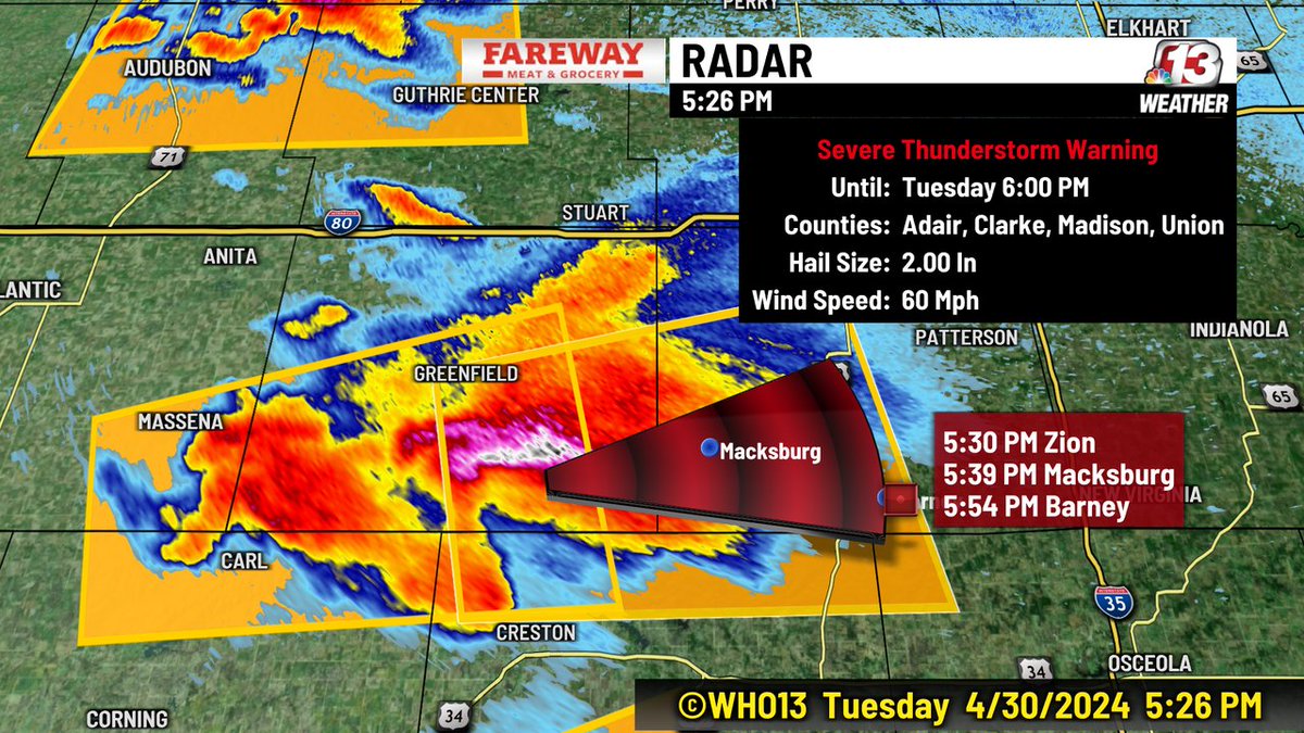
There are multiple Severe Thunderstorm Warnings for the areas of Decatur, Madison, Union, Ringgold, Clarke, Adair and Adams Counties in southern Iowa. The biggest threat is large hail and damaging wind. These storms are rebuilding to the west and moving east.

There are multiple Severe Thunderstorm Warnings for the areas of Decatur, Madison, Union, Ringgold, Clarke, Adair and Adams Counties in southern Iowa. The biggest threat is large hail and damaging wind. These storms are rebuilding to the west and moving east.
account_circle
Ed Wilson(@EdWilsonWX13HD) 's Twitter Profile Photo

The Waring continues for Adair, Clarke, Madison, Union. Large hail and damaging wind continues to be the biggest threat.

The Waring continues for Adair, Clarke, Madison, Union. Large hail and damaging wind continues to be the biggest threat.
account_circle
Ed Wilson(@EdWilsonWX13HD) 's Twitter Profile Photo

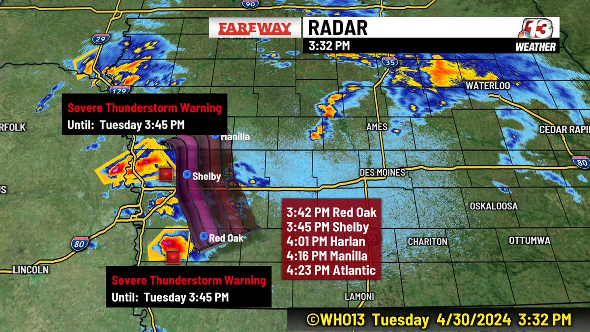
A Severe Thunderstorm Warning has been issued for Crawford County in western Iowa until 4:45 PM. It is moving to the NNE at 35 MPH. Large hail and damaging wind can be expected with this storm.

A Severe Thunderstorm Warning has been issued for Crawford County in western Iowa until 4:45 PM. It is moving to the NNE at 35 MPH. Large hail and damaging wind can be expected with this storm.
account_circle
Ed Wilson(@EdWilsonWX13HD) 's Twitter Profile Photo

A Severe Thunderstorm Warning has been issued for Adams and Cass County in SW until 4:45 PM. The storm is moving out of a tornado warning at around 35 MPH. Large hail and damaging wind is expected.

A Severe Thunderstorm Warning has been issued for Adams and Cass County in SW until 4:45 PM. The storm is moving out of a tornado warning at around 35 MPH. Large hail and damaging wind is expected.
account_circle
Ed Wilson(@EdWilsonWX13HD) 's Twitter Profile Photo

There is a Tornado Warning in effect until 4:15 for Mills, Montgomery and Pottawattamie Counties. The tornado warning is just outside our viewing area...but that line of storms continues to move to the NE at 30-40 MPH. We have a tornado watch in effect until 10 PM.

There is a Tornado Warning in effect until 4:15 for Mills, Montgomery and Pottawattamie Counties. The tornado warning is just outside our viewing area...but that line of storms continues to move to the NE at 30-40 MPH. We have a tornado watch in effect until 10 PM.
account_circle
Ed Wilson(@EdWilsonWX13HD) 's Twitter Profile Photo

Two very strong thunder storms in western Iowa are moving WNW at 30 MPH. These are severe thunderstorms with damaging wind and large hail. The northern storm is moving toward the same area which had the tornadoes last Friday.

Two very strong thunder storms in western Iowa are moving WNW at 30 MPH. These are severe thunderstorms with damaging wind and large hail. The northern storm is moving toward the same area which had the tornadoes last Friday.
account_circle
Ed Wilson(@EdWilsonWX13HD) 's Twitter Profile Photo

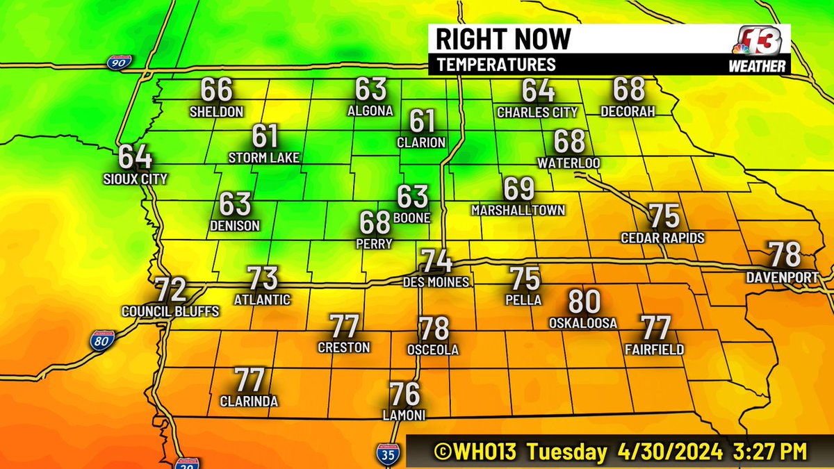
Temperatures have warmed into the upper 70s and low 80s over southern Iowa. This heat will add fuel to the severe storms later this evening.

Temperatures have warmed into the upper 70s and low 80s over southern Iowa. This heat will add fuel to the severe storms later this evening.
account_circle
Ed Wilson(@EdWilsonWX13HD) 's Twitter Profile Photo

There is a Tornado Watch in effect for the southwest half of Iowa through 10 PM. This watch includes the Des Moines' Metro. Be ready to seek shelter if there is a tornado warning for your area.

There is a Tornado Watch in effect for the southwest half of Iowa through 10 PM. This watch includes the Des Moines' Metro. Be ready to seek shelter if there is a tornado warning for your area.
account_circle
Ed Wilson(@EdWilsonWX13HD) 's Twitter Profile Photo

We have seen a couple strong to severe storms this afternoon in western iowa. There is an area of clearing over counties in the SW corn of the state. This area is becoming unstable, Storms will start to develop in this area. We are looking for a Tornado Watch to be issued.

We have seen a couple strong to severe storms this afternoon in western iowa. There is an area of clearing over counties in the SW corn of the state. This area is becoming unstable, Storms will start to develop in this area. We are looking for a Tornado Watch to be issued.
account_circle
Ed Wilson(@EdWilsonWX13HD) 's Twitter Profile Photo

After Keith Murphy returned from Japan and before our severe weather outbreak, we had a minute to catch-up with each other on Off The Cuff With Ed and Murph. WHO 13 News who13.com/news/digital-o…

account_circle
Ed Wilson(@EdWilsonWX13HD) 's Twitter Profile Photo

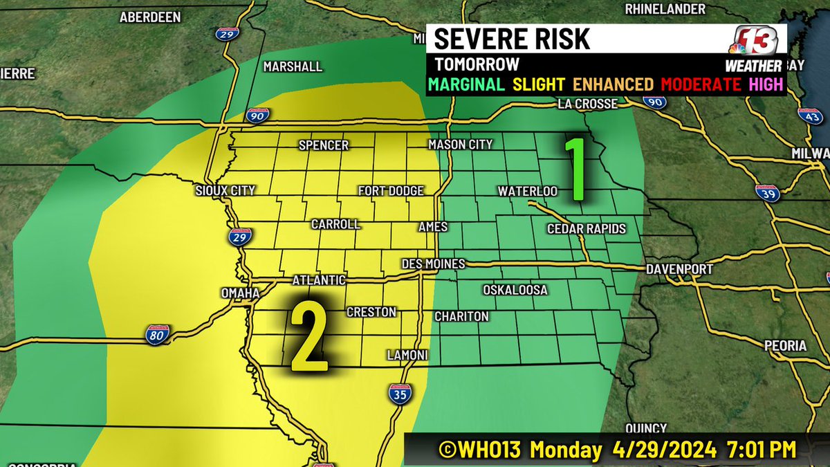
We have a chance for more strong storms tomorrow afternoon and evening. Right now there is a level 2 (Slight) chance for storms with damaging wind and large hail. An isolated tornado is also possible.

We have a chance for more strong storms tomorrow afternoon and evening. Right now there is a level 2 (Slight) chance for storms with damaging wind and large hail. An isolated tornado is also possible.
account_circle