Max Golembo(@Wx_Max) 's Twitter Profileg
Max Golembo

@Wx_Max

Senior Meteorologist/Weather Producer for ABC News and Good Morning America. UAlbany Grad

ID:1346942144

calendar_today12-04-2013 14:21:25

52,7K Tweets

4,7K Followers

5,2K Following

NWS Storm Prediction Center(@NWSSPC) 's Twitter Profile Photo

An active period of severe weather is expected Thu through the weekend across the Plains. All severe hazards are possible with the potential for significant severe weather. Specific corridors of greater risk are expected, but will not become more apparent until later in the week.

An active period of severe weather is expected Thu through the weekend across the Plains. All severe hazards are possible with the potential for significant severe weather. Specific corridors of greater risk are expected, but will not become more apparent until later in the week.
account_circle
NWS GSP(@NWSGSP) 's Twitter Profile Photo

Please understand that we don't want anyone to feel like the damage is being minimized. This was a very rare and significant event and likely the worst storm that many citizens in the impacted communities have ever seen in their lifetime.

account_circle
NWS GSP(@NWSGSP) 's Twitter Profile Photo

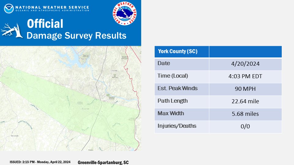
With that being said, after thorough investigation of the damage and available data, we determined that an intense swath of 70-90 mph straight line winds resulted in extensive damage extending from the city of York, through Rock Hill and continuing to the Lancaster County line.

With that being said, after thorough investigation of the damage and available data, we determined that an intense swath of 70-90 mph straight line winds resulted in extensive damage extending from the city of York, through Rock Hill and continuing to the Lancaster County line.
account_circle
NWS GSP(@NWSGSP) 's Twitter Profile Photo

In addition, there was very large hail ranging from 2-2.75 inches (hen egg to baseball size) that was being driven by the wind. This wind-driven hail further exacerbated damage to trees, structures and vehicles.

account_circle
NWS GSP(@NWSGSP) 's Twitter Profile Photo

During a tornado, the damage patterns are convergent as winds blow in towards the tornado center - this was not observed in the damage across York County.

During a tornado, the damage patterns are convergent as winds blow in towards the tornado center - this was not observed in the damage across York County.
account_circle
NWS GSP(@NWSGSP) 's Twitter Profile Photo

The environment at the time was not supportive of tornadoes with a lack of wind shear in the lowest levels of the storm necessary for the formation of tornadoes. Data from multiple radars also did not indicate any low-level rotation that would indicate a possible tornado.

account_circle
NWS GSP(@NWSGSP) 's Twitter Profile Photo

When conducting the damage survey, it was noted that damage to structures was mainly confined to one side of the building with trees also blown down in one direction.

account_circle
NWS GSP(@NWSGSP) 's Twitter Profile Photo

The width of the damage swath of was also very wide at over 5.5 miles. For reference, the widest tornado on record is 2.6 miles.

account_circle
NWS GSP(@NWSGSP) 's Twitter Profile Photo

We hope that this thread helps to clear up any confusion regarding the storm that impacted York County on Saturday. This was a very rare storm for the Carolinas that produced damage more commonly seen in the Great Plains and Midwest.

account_circle
NWS GSP(@NWSGSP) 's Twitter Profile Photo

We also understand that there were personal accounts of a tornado being seen. Storms frequently contain what are referred to as 'scud' clouds. Scud clouds are commonly confused with tornadoes as they are ragged and hang very low from the storm giving the impression of a tornado.

account_circle
ABC News Live(@ABCNewsLive) 's Twitter Profile Photo

.Ginger Zee traveled to Taos, New Mexico to stay with the Earthships community and find out what everyone can be doing to live a bit more sustainably. trib.al/7w7YMgC

account_circle
NWS Mount Holly(@NWS_MountHolly) 's Twitter Profile Photo

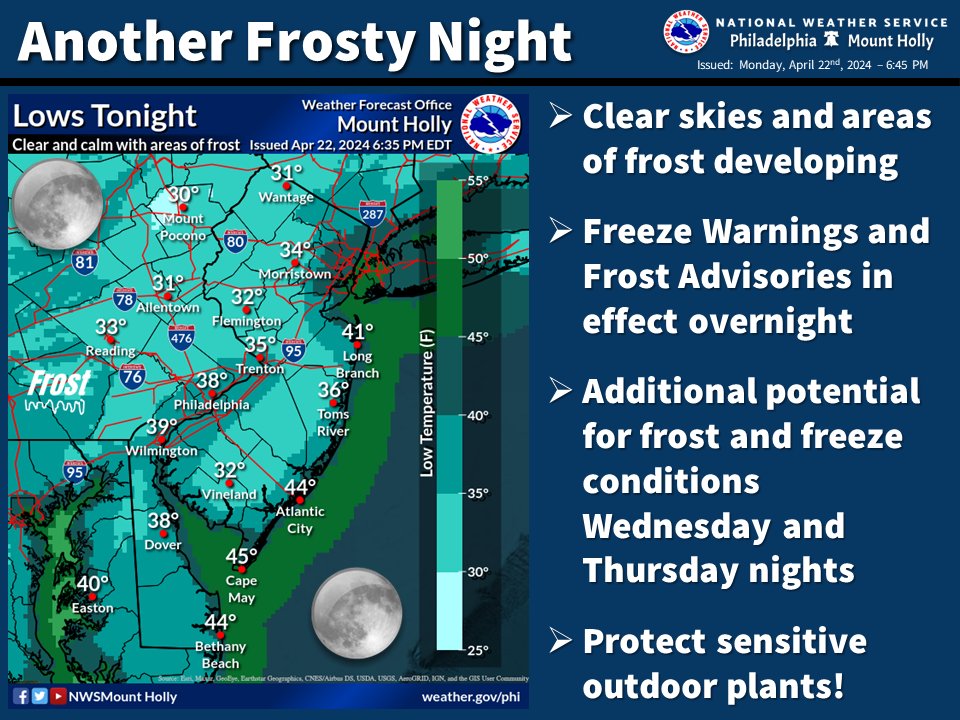
🥶 Another frosty night is forecast for much of the area. Freeze Warnings and Frost Advisories are in effect overnight for most areas away from the immediate coast. Tuesday night will be mild, then frost/freeze conditions return later this week.

🥶 Another frosty night is forecast for much of the area. Freeze Warnings and Frost Advisories are in effect overnight for most areas away from the immediate coast. Tuesday night will be mild, then frost/freeze conditions return later this week. #PAwx #NJwx #DEwx #MDwx
account_circle
Oklahoma Mesonet(@okmesonet) 's Twitter Profile Photo

We prefer Elmer Fudd season. At any rate, be vewy vewy weather aware later this week! Typical spring pattern setting up into the weekend. ticker.mesonet.org

We prefer Elmer Fudd season. At any rate, be vewy vewy weather aware later this week! Typical spring pattern setting up into the weekend. ticker.mesonet.org #okwx #okmesonet
account_circle
NWS Albany(@NWSAlbany) 's Twitter Profile Photo

With 14.94' of precipitation as of Apr 20 2024, this year ranks as the 4th wettest start to a calendar year for Albany since 1874. Here's a look at year to date precipitation compared to the last 5 years & to normal (10.13'). We're 4.81' wetter than normal!

With 14.94' of precipitation as of Apr 20 2024, this year ranks as the 4th wettest start to a calendar year for Albany since 1874. Here's a look at year to date precipitation compared to the last 5 years & to normal (10.13'). We're 4.81' wetter than normal!#nywx #ctwx #vtwx #mawx
account_circle
NWS Weather Prediction Center(@NWSWPC) 's Twitter Profile Photo

Saturday April 20, 2024 Lower 48 Temperature Extremes:

6F -- 20 miles WSW of Dubois, WY
101F -- Death Valley, CA

A 95F range

Saturday April 20, 2024 Lower 48 Temperature Extremes: 6F -- 20 miles WSW of Dubois, WY 101F -- Death Valley, CA A 95F range
account_circle
NWS Las Vegas(@NWSVegas) 's Twitter Profile Photo

Las Vegas has officially reach its first 90° temp, which occurred at 4:44 PM today. The average first date is April 15. The earliest 90° occurred on March 13, 2007 and the latest was May 21, 1983.

account_circle
Matthew East(@eastwx) 's Twitter Profile Photo

Damaging hail has unfortunately occurred with some of the storms today. This video is from our engineer-extraordinaire Mark Smith in Rock Hill

account_circle