NASA Earth(@NASAEarth) 's Twitter Profile Photo

Destructive flooding in Brazil ⤵️

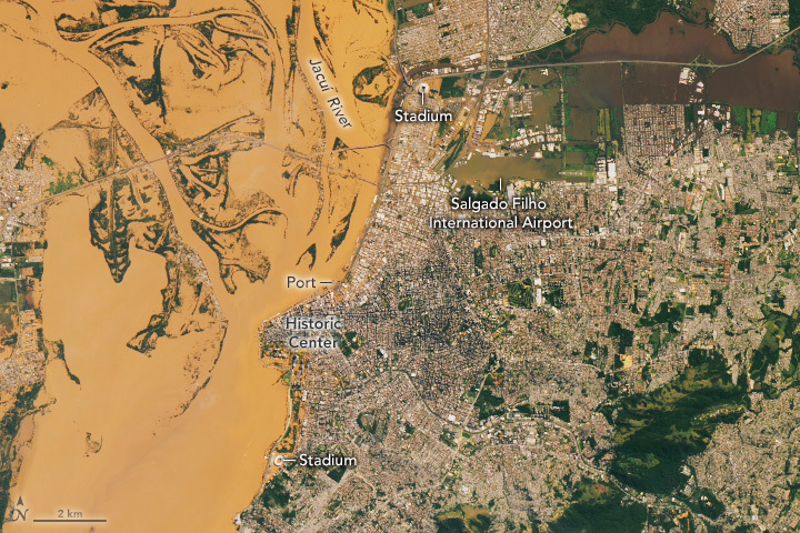
Strong storms brought torrential rain to Rio Grande do Sul. In some areas, more than 300 millimeters (12 inches) of rain fell in less than a week. captured Porto Alegre’s flooded downtown area on May 8. go.nasa.gov/4alOu9y

Destructive flooding in Brazil ⤵️

Strong storms brought torrential rain to Rio Grande do Sul. In some areas, more than 300 millimeters (12 inches) of rain fell in less than a week. #Landsat captured Porto Alegre’s flooded downtown area on May 8. go.nasa.gov/4alOu9y
account_circle
Una finestra des de l'espai(@UEspai) 's Twitter Profile Photo

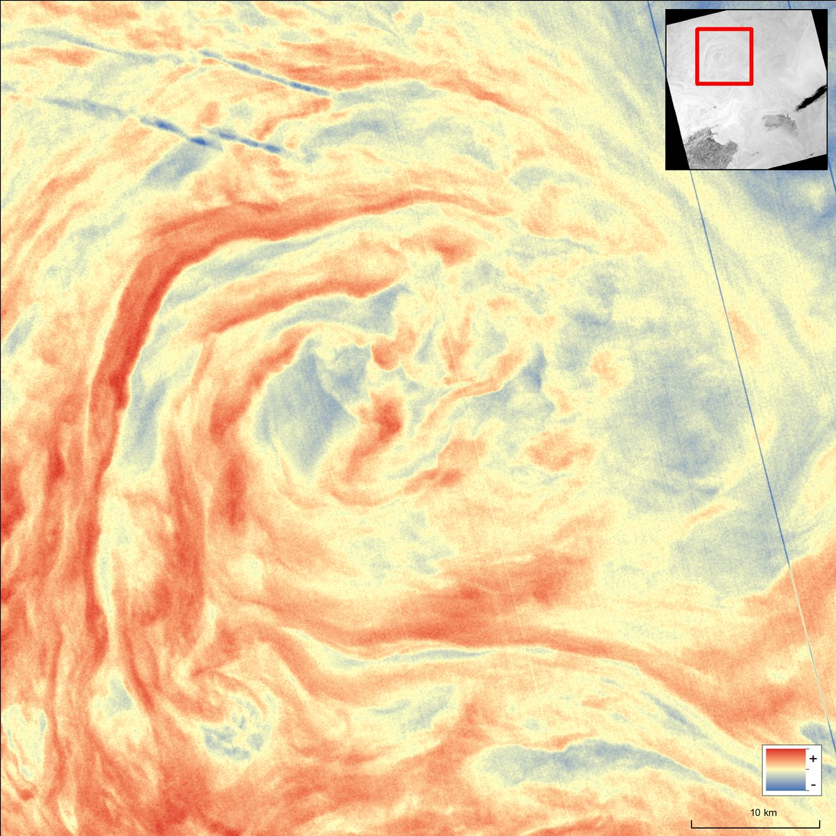
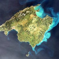
La teledetecció és una eina molt valuosa per analitzar la dinàmica dels oceans. Fixau-vos en aquesta preciosa imatge del mes d'abril captada pel satèl·lit Landsat, on el seu sensor registra la temperatura de la superfície del mar, dibuixant un bell remolí a la mar Balear.

La teledetecció és una eina molt valuosa per analitzar la dinàmica dels oceans. Fixau-vos en aquesta preciosa imatge del mes d'abril captada pel satèl·lit Landsat, on el seu sensor registra la temperatura de la superfície del mar, dibuixant un bell remolí a la mar Balear.
account_circle
NASA Landsat(@NASA_Landsat) 's Twitter Profile Photo

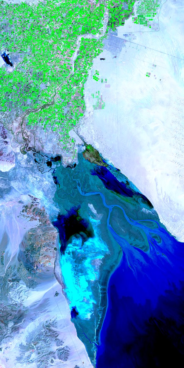
The mighty Colorado—sculptor of the Grand Canyon—no longer meets the sea at the river’s Mexican terminus: the long, narrow Gulf of California where a vast delta (likened to the Nile’s) once existed.

The river is fully consumed before getting there.

A look:

The mighty Colorado—sculptor of the Grand Canyon—no longer meets the sea at the river’s Mexican terminus: the long, narrow Gulf of California where a vast delta (likened to the Nile’s) once existed.

The river is fully consumed before getting there.

A #Landsat look:
account_circle
NASA Landsat(@NASA_Landsat) 's Twitter Profile Photo

penguins can provide unique information about Antarctica? 🐧

Using NASA Earth data from missions like , Heather Lynch, professor at SBU, developed Mapping Application for Penguin Populations & Projected Dynamics (MAPPPD) to track penguins & ecosystem health.

account_circle
Ken Mubea(@kenmubea) 's Twitter Profile Photo

📢 🌍🛰️ Digital Earth Africa platform, powered by Amazon Web Services , is now providing free access to historic satellite data for . This empowers countries to assess the impacts of climate change. For instance, the Digital Earth Africa water observation from space using USGS Landsat

account_circle
RCMRD 🇰🇪 🇺🇬 🇸🇴 🇹🇿 🇲🇼 🇰🇲 🇿🇲 🇱🇸 🇸🇿(@RCMRD_) 's Twitter Profile Photo

Digital Earth Africa & RCMRD are using    data to map -risk areas in Nairobi County, Kenya, for the March-May long rains, leveraging 8 data, elevation data from NASA SRTM DEM at 30 metres & the EU Joint Research Centre's Global Surface Water dataset.
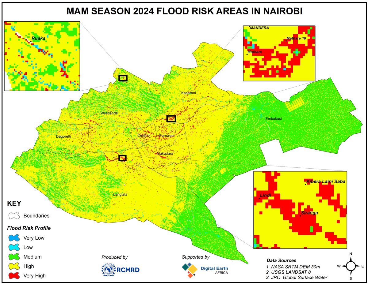
@DEarthAfrica & RCMRD are using #EarthObservation  data to map #flood-risk areas in Nairobi County, Kenya, for the March-May long rains, leveraging #Landsat 8 data, elevation data from NASA SRTM DEM at 30 metres & the EU Joint Research Centre's Global Surface Water dataset.
account_circle
Alba Viana Soto(@albaa_vs) 's Twitter Profile Photo

Can we predict long-term forest recovery success using post-disturbance characteristics? 🛰️🌲Check out the latest paper, using spectral unmixing of Landsat/Sentinel2 data, brilliantly led by Lisa Mandl !! doi.org/10.1016/j.rse.…
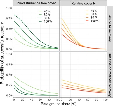
Can we predict long-term forest recovery success using post-disturbance characteristics? 🛰️🌲Check out the latest paper, using spectral unmixing of Landsat/Sentinel2 data, brilliantly led by @_lisamandl !! doi.org/10.1016/j.rse.…
account_circle
Lorentzův faktor(@LorentzuvFaktor) 's Twitter Profile Photo

📌 Ničivé záplavy v Brazílii 🌎🌊
Silné bouře přinesly do 'Rio Grande do Sul' přívalové deště, v některých oblastech spadlo za necelý týden více než 300 milimetrů srážek. 🛰️ zachytila 8. května zaplavené centrum Porto Alegre.
👇
earthobservatory.nasa.gov/images/152795/…
👇...pěkné🧵uvnitř

account_circle
USGS Landsat(@USGSLandsat) 's Twitter Profile Photo

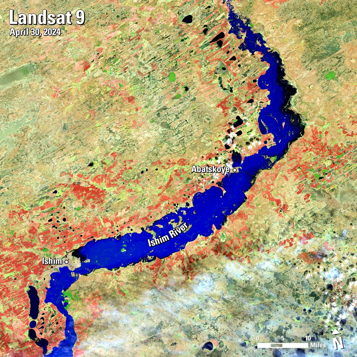
Unseasonably warm temperatures, melting snow, and heavy rainfall have triggered record-breaking in and . recently captured the floodwaters of the surging north toward the village of .

Unseasonably warm temperatures, melting snow, and heavy rainfall have triggered record-breaking #floods in #Russia and #Kazakhstan. #Landsat recently captured the floodwaters of the #IshimRiver surging north toward the village of #Abatskoye.
account_circle
MT Anderson(@MT_Anderson) 's Twitter Profile Photo

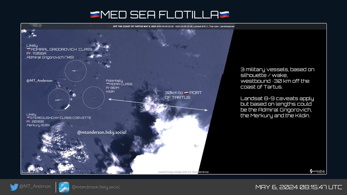
🇷🇺MED SEA FLOTILLA🇷🇺
3 military vessels, based on silhouette / wake, westbound ~30 km off the coast of Tartus.

Landsat 8-9 caveats apply but based on lengths could be the Admiral Grigorovich, the Merkury and the Kildin.

It will be interesting to see what's left in Tartus🧐

🇷🇺MED SEA FLOTILLA🇷🇺
3 military vessels, based on silhouette / wake, westbound ~30 km off the coast of Tartus.

Landsat 8-9 caveats apply but based on lengths could be the Admiral Grigorovich, the Merkury and the Kildin.

It will be interesting to see what's left in Tartus🧐
account_circle
NASA Earth(@NASAEarth) 's Twitter Profile Photo

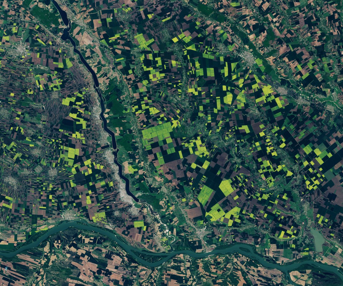
Want to go for a walk in fields of green and gold? 🌱🌼

In Romania, green agricultural fields became tinged with yellow as plants bloomed. On April 12, the satellite captured these pops of color near the Olt and Danube rivers. go.nasa.gov/4aZYExn

Want to go for a walk in fields of green and gold? 🌱🌼

In Romania, green agricultural fields became tinged with yellow as plants bloomed. On April 12, the #Landsat satellite captured these pops of color near the Olt and Danube rivers. go.nasa.gov/4aZYExn
account_circle
MT Anderson(@MT_Anderson) 's Twitter Profile Photo

*UPDATE: CSG 2 Suez Southbound*

🇺🇸CARRIER STRIKE GROUP 2🇺🇸
Look who is heading back to the Red Sea!

USS Dwight D. Eisenhower (IKE) & an Arleigh Burke Class destroyer (USS Gravely?) are southbound in the Suez Canal (just exiting the Great Bitter Lake)

5 May 2024: Landsat 8-9
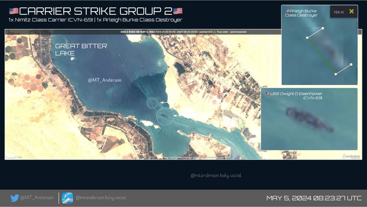
*UPDATE: CSG 2 Suez Southbound*

🇺🇸CARRIER STRIKE GROUP 2🇺🇸
Look who is heading back to the Red Sea! 

@TheCVN69 & an Arleigh Burke Class destroyer (USS Gravely?) are southbound in the Suez Canal (just exiting the Great Bitter Lake)

5 May 2024: Landsat 8-9

account_circle
منصة نظم المعلومات الجغرافية GIS(@gis_eductation) 's Twitter Profile Photo

مواقع لتحميل المرئيات الفضائية
EOSDA LandViewer
موقع يوفر واجهة مستخدم للوصول إلى صور الأقمار الصناعية والبيانات الجغرافية المتعلقة بالأرض، يوفر تجربة تفاعلية للمستخدمين لتحميل وتصفح الصور الفضائية عالية الدقة من مصادر مختلفة
Sentinel-2 Landsat و MODIS
eos.com/landviewer/

مواقع لتحميل المرئيات الفضائية
EOSDA LandViewer
 موقع يوفر واجهة مستخدم للوصول إلى صور الأقمار الصناعية والبيانات الجغرافية المتعلقة بالأرض، يوفر تجربة تفاعلية للمستخدمين لتحميل وتصفح الصور الفضائية عالية الدقة من مصادر مختلفة
 Sentinel-2 Landsat و MODIS 
 eos.com/landviewer/
account_circle
dino - dobra espacial 🚀(@tomatosmat) 's Twitter Profile Photo

O satélite Landsat 8, da NASA, capturou essa imagem de Porto Alegre ontem.

Impressionante ver até onde a água chegou

account_circle
USGS Landsat(@USGSLandsat) 's Twitter Profile Photo

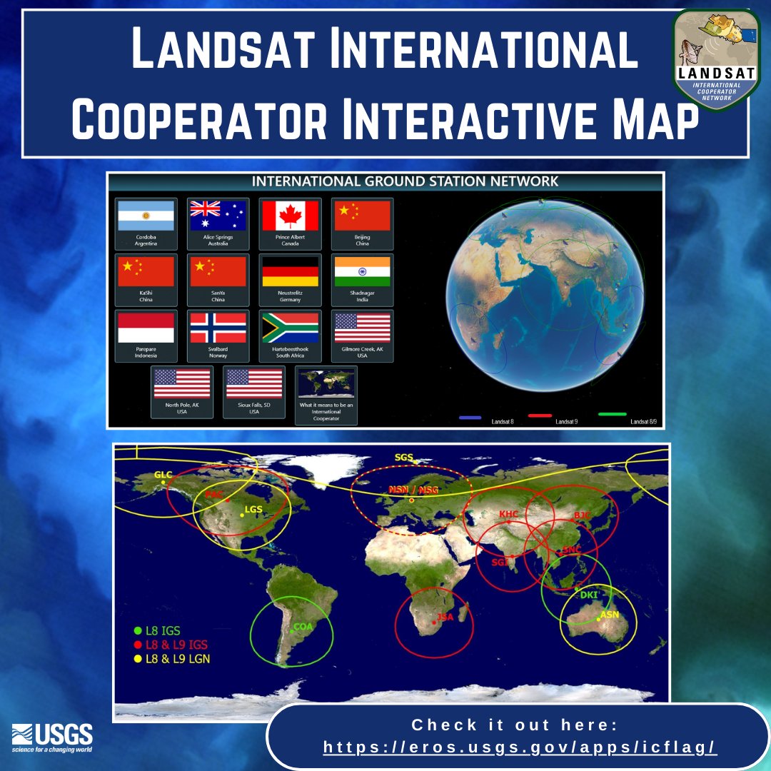
Landsat has always been an important part to U.S. Foreign policy, science, and technology policy with the network of International Cooperators (IC’s) and their International Ground Stations. Learn more by visiting the Landsat IC interactive map: ow.ly/M4pa50RAJBY

Landsat has always been an important part to U.S. Foreign policy, science, and technology policy with the network of International Cooperators (IC’s) and their International Ground Stations.  Learn more by visiting the Landsat IC interactive map: ow.ly/M4pa50RAJBY
account_circle
Imtiaz Mahmood(@ImtiazMadmood) 's Twitter Profile Photo

Valerie L. Thomas is an American data scientist and inventor. She invented the illusion transmitter, for which she received a patent in 1980. She was responsible for developing the digital media formats that image processing systems used in the early years of NASA's Landsat…

Valerie L. Thomas is an American data scientist and inventor. She invented the illusion transmitter, for which she received a patent in 1980. She was responsible for developing the digital media formats that image processing systems used in the early years of NASA's Landsat…
account_circle
Cornelius Senf(@corneliussenf) 's Twitter Profile Photo

And the last 📝 for this week: using Landsat we show an increasing sensitivity of grasslands to hotter droughts, fabulously lead by Katja Kowalski and published in Global Change Biology today: onlinelibrary.wiley.com/doi/epdf/10.11…
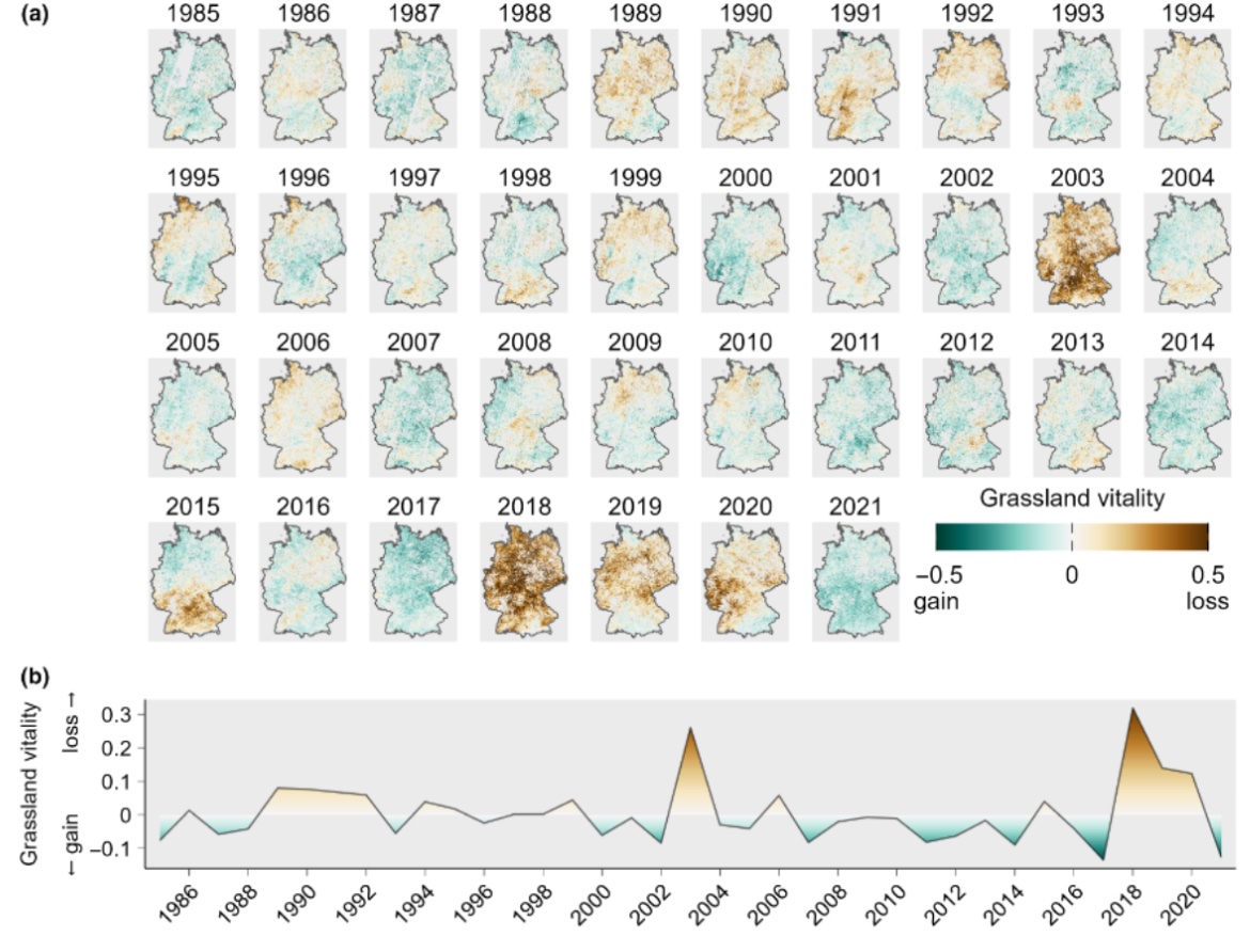
And the last 📝 for this week:  using Landsat we show an increasing sensitivity of grasslands to hotter droughts, fabulously lead by @katja_kowalski and published in @GlobalChangeBio today: onlinelibrary.wiley.com/doi/epdf/10.11…
account_circle