Pete Delkus(@wfaaweather) 's Twitter Profileg
Pete Delkus

@wfaaweather

I'm just your weather guy.

ID:15937025

linkhttps://www.wfaa.com/article/about-us/team-bios/pete-delkus/287-28580021 calendar_today21-08-2008 21:15:45

73,1K Tweets

453,6K Followers

153 Following

Pete Delkus(@wfaaweather) 's Twitter Profile Photo

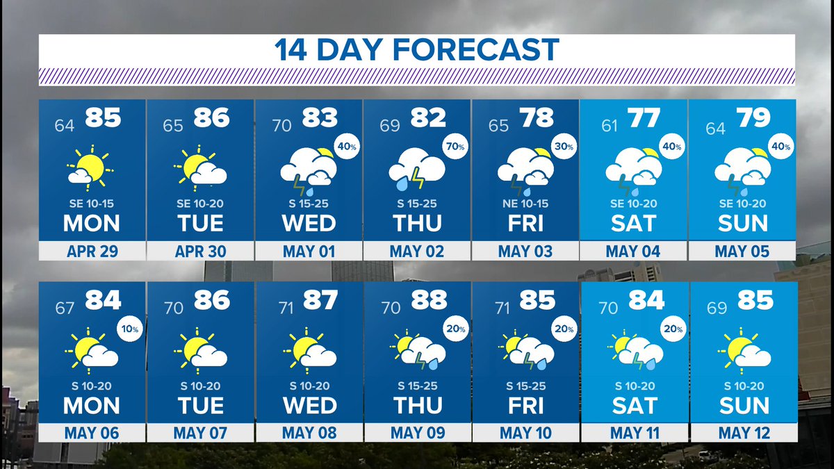
The second half of this week through this weekend looks messy. That means each day features rain somewhere in North Texas with varying levels of coverage. It'll be hard to nail down exact timing and coverage each day so we'll just have to take it one day at a time.

account_circle
Pete Delkus(@wfaaweather) 's Twitter Profile Photo

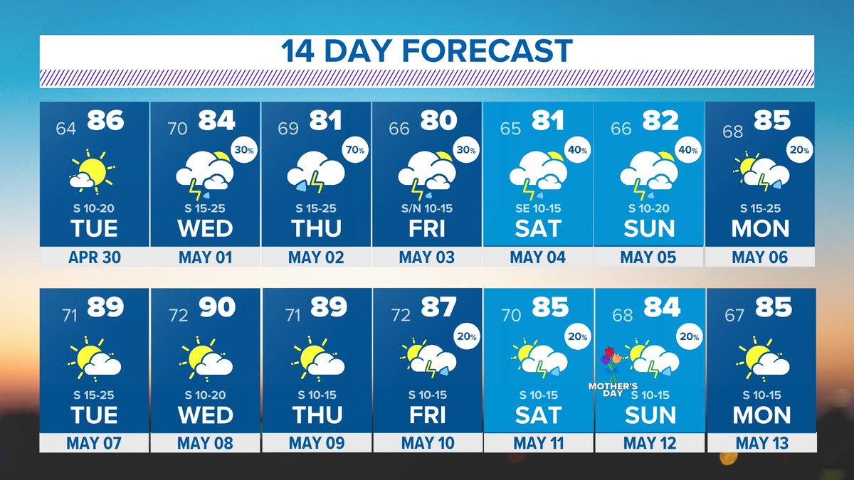
Here we go again! It may not happen all at once, but between Wednesday and Sunday around 2-3in of rain is possible in North Texas. Given how wet things have been recently, we'll have to keep an eye on any flooding issues that may pop up through the weekend.

Here we go again! It may not happen all at once, but between Wednesday and Sunday around 2-3in of rain is possible in North Texas. Given how wet things have been recently, we'll have to keep an eye on any flooding issues that may pop up through the weekend.
account_circle
Pete Delkus(@wfaaweather) 's Twitter Profile Photo

TUESDAY: The morning could start off with some patchy fog which will give way to afternoon sunshine and warm temps (80s). A few weakening storms could move into far western North Texas during the nighttime hours, but even in that area most will stay dry.

TUESDAY: The morning could start off with some patchy fog which will give way to afternoon sunshine and warm temps (80s). A few weakening storms could move into far western North Texas during the nighttime hours, but even in that area most will stay dry. #wfaaweather
account_circle
Pete Delkus(@wfaaweather) 's Twitter Profile Photo

As we head farther into spring, the tree pollen will start to decrease and the grass pollen will increase until we get to summer.

As we head farther into spring, the tree pollen will start to decrease and the grass pollen will increase until we get to summer. #wfaaweather
account_circle
Pete Delkus(@wfaaweather) 's Twitter Profile Photo

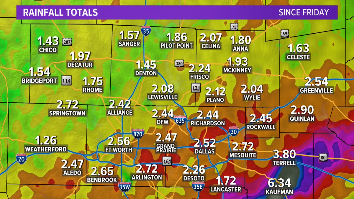
Big rain totals in North Texas since Friday. Some locations in between these observation sites, especially southeast of the metroplex, saw as much as 7'-8' of rain.

Big rain totals in North Texas since Friday. Some locations in between these observation sites, especially southeast of the metroplex, saw as much as 7'-8' of rain. #wfaaweather
account_circle
Pete Delkus(@wfaaweather) 's Twitter Profile Photo

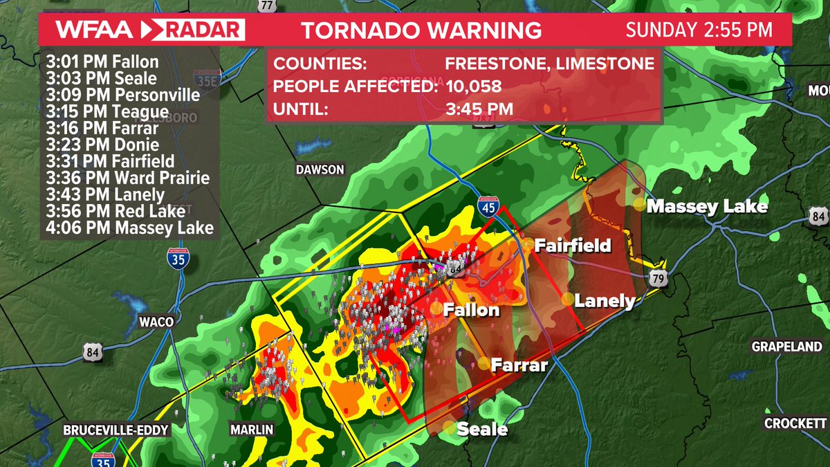
A tornado warning has been issued in Limestone and Freestone Counties. Spotters have reported a funnel in the warned area.

A tornado warning has been issued in Limestone and Freestone Counties. Spotters have reported a funnel in the warned area. #wfaaweather
account_circle
Pete Delkus(@wfaaweather) 's Twitter Profile Photo

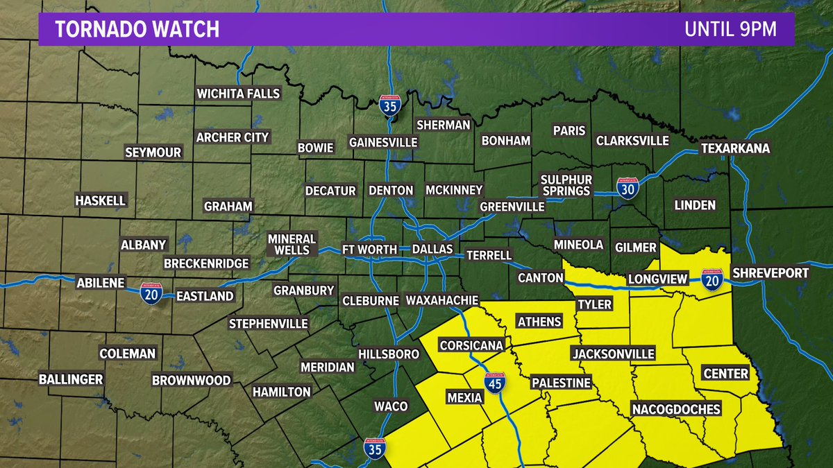
Good afternoon, everyone. Most of North Texas will remain quiet the rest of the day. Areas to the southeast of the metroplex will have the risk for severe weather again. A tornado watch has been issued for Henderson and Navarro Counties until 9 PM.

Good afternoon, everyone. Most of North Texas will remain quiet the rest of the day. Areas to the southeast of the metroplex will have the risk for severe weather again. A tornado watch has been issued for Henderson and Navarro Counties until 9 PM. #wfaaweather
account_circle
Pete Delkus(@wfaaweather) 's Twitter Profile Photo

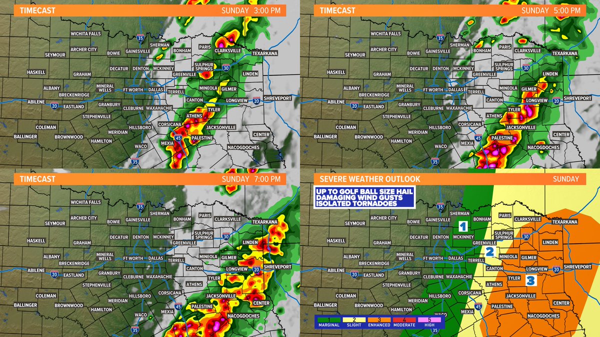
REST OF SUNDAY: It is not impossible for a few storms to develop from DFW to the east through mid-afternoon, but the higher severe threat and storm chances will remain to the east in East Texas. DFW has a good chance to stay mainly dry Sunday afternoon into evening.

REST OF SUNDAY: It is not impossible for a few storms to develop from DFW to the east through mid-afternoon, but the higher severe threat and storm chances will remain to the east in East Texas. DFW has a good chance to stay mainly dry Sunday afternoon into evening. #wfaaweather
account_circle
Pete Delkus(@wfaaweather) 's Twitter Profile Photo

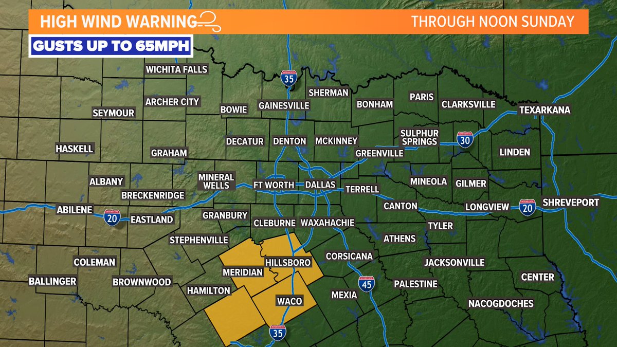
Decaying thunderstorms are producing strong winds in southern North Texas into Central Texas. A High Wind Warning is in effect until noon for gusts up to 65mph in those areas.

Decaying thunderstorms are producing strong winds in southern North Texas into Central Texas. A High Wind Warning is in effect until noon for gusts up to 65mph in those areas. #wfaaweather
account_circle
Pete Delkus(@wfaaweather) 's Twitter Profile Photo

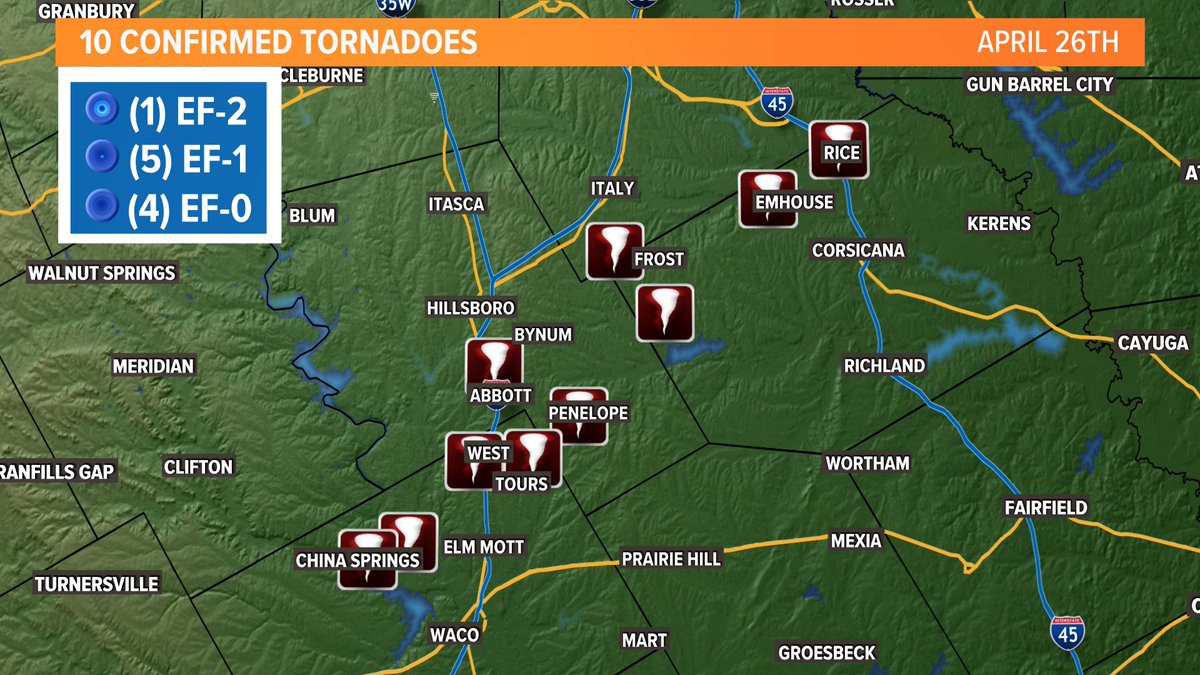
TEN tornadoes have been confirmed from Friday's storms in Central and North Texas spread across Navarro, Hill, and McLennan counties. The strongest was an EF-2 north of Tours that tracked into southern Hill County near Penelope with winds of up to 115mph.

TEN tornadoes have been confirmed from Friday's storms in Central and North Texas spread across Navarro, Hill, and McLennan counties. The strongest was an EF-2 north of Tours that tracked into southern Hill County near Penelope with winds of up to 115mph.
account_circle
Pete Delkus(@wfaaweather) 's Twitter Profile Photo

New Flash Flood Warning has been issued for Kaufman County until 11:15am. Repeated rounds of rain on already saturated ground from Friday's storms could cause flooding. Do not drive into or through flooded roadways!

Radar: wfaa.com/radar

New Flash Flood Warning has been issued for Kaufman County until 11:15am. Repeated rounds of rain on already saturated ground from Friday's storms could cause flooding. Do not drive into or through flooded roadways! Radar: wfaa.com/radar
account_circle
Pete Delkus(@wfaaweather) 's Twitter Profile Photo

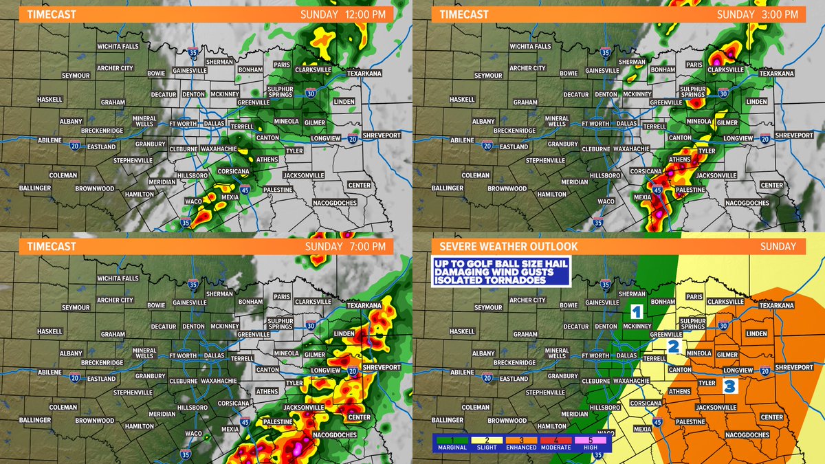
REST OF SUNDAY: Morning storms will keep moving east. Some afternoon/evening redevelopment possible mainly across eastern North Texas and especially East Texas. Chances aren't zero for DFW, but they are low. West of DFW will be dry the rest of today.

REST OF SUNDAY: Morning storms will keep moving east. Some afternoon/evening redevelopment possible mainly across eastern North Texas and especially East Texas. Chances aren't zero for DFW, but they are low. West of DFW will be dry the rest of today. #wfaaweather
account_circle
Pete Delkus(@wfaaweather) 's Twitter Profile Photo

I never sleep when severe weather is happening!
Although, I do briefly close one eye, when the gates of hell are wide open in July and August!

account_circle