
ATCEMS(@ATCEMS) 's Twitter Profileg
ATCEMS

@ATCEMS

Official breaking news, weather & safety messaging from Austin-Travis County EMS. To check on hiring opportunities go to: https://t.co/7ehPe6TBc4

ID:394077010

linkhttps://www.austintexas.gov/content/ems-austin-travis-county calendar_today19-10-2011 14:51:55

19,7K Tweets

59,5K Followers

259 Following

ATCEMS(@ATCEMS) 's Twitter Profile Photo

A special weather statement has been issued for Austin TX, Pflugerville TX and Wells Branch TX until 8:00 PM CDT

account_circle
ATCEMS(@ATCEMS) 's Twitter Profile Photo

A Flood Watch is in effect through 7 AM Thursday for possible areas of heavy rainfall. Isolated amounts up to 5 inches will be possible in the watch area.

account_circle
ATCEMS(@ATCEMS) 's Twitter Profile Photo

Vehicle Rescue at 7700 N Mopac Expy Sb (in express lane, 09:10). & Austin Fire Info are on scene of a 2 vehicle collision w/1 that rolled over. Medics reporting 1 patient involved, who has been extricated from their vehicle. Expect delays, more to follow

account_circle
ATCEMS(@ATCEMS) 's Twitter Profile Photo

responded to this collision (x-st Oltorf, 22:09) for reports of multiple vehicles involved, with one that rolled over. Medics treated a total of 4 patients. 2 adults were transported to Dell Seton with potentially serious injuries, & 2 adults refused EMS transport.

account_circle
ATCEMS(@ATCEMS) 's Twitter Profile Photo

MEDIA: will hold a media briefing at 8 p.m. to update the public on the outbreak of unintentional opioid overdoses that have occurred and are still occurring today, at EMS Headquarters (15 Waller St.). Please contact EMS PIO to RSVP.

account_circle
ATCEMS(@ATCEMS) 's Twitter Profile Photo

A special weather statement has been issued for Round Rock TX, Pflugerville TX and Brushy Creek TX until 9:15 AM CDT

account_circle
ATCEMS(@ATCEMS) 's Twitter Profile Photo

Severe Thunderstorm Warning including Austin TX, New Braunfels TX and San Marcos TX until 8:45 AM CDT

account_circle
ATCEMS(@ATCEMS) 's Twitter Profile Photo

A special weather statement has been issued for San Antonio TX, Austin TX and Round Rock TX until 8:45 AM CDT

account_circle
ATCEMS(@ATCEMS) 's Twitter Profile Photo

If you're alerted to a Tornado Warning, shelter IMMEDIATELY.

Wait to check other sources for info while in your safe place.

account_circle
ATCEMS(@ATCEMS) 's Twitter Profile Photo

Are Wireless Emergency Alerts enabled on your phone? They could save your life!
Learn more at: weather.gov/wrn/wea

What about Warn Central Texas? warncentraltexas.org

account_circle
ATCEMS(@ATCEMS) 's Twitter Profile Photo

Do you have one? You can buy one tax free this weekend!

and be prepared for the next weather emergency.

You can also buy other emergency preparedness supplies. Here's a list of items you can get: comptroller.texas.gov/taxes/publicat…

account_circle
ATCEMS(@ATCEMS) 's Twitter Profile Photo

: Severe thunderstorms possible late Sat night thru Sun, capable of large/very lrg hail, damaging wind, isolated tornadoes. Timing graphic was adjusted for later arrival, & level 2/5 risk introduced to far North portions of I35 corridor & Coastal Plains for Sunday.
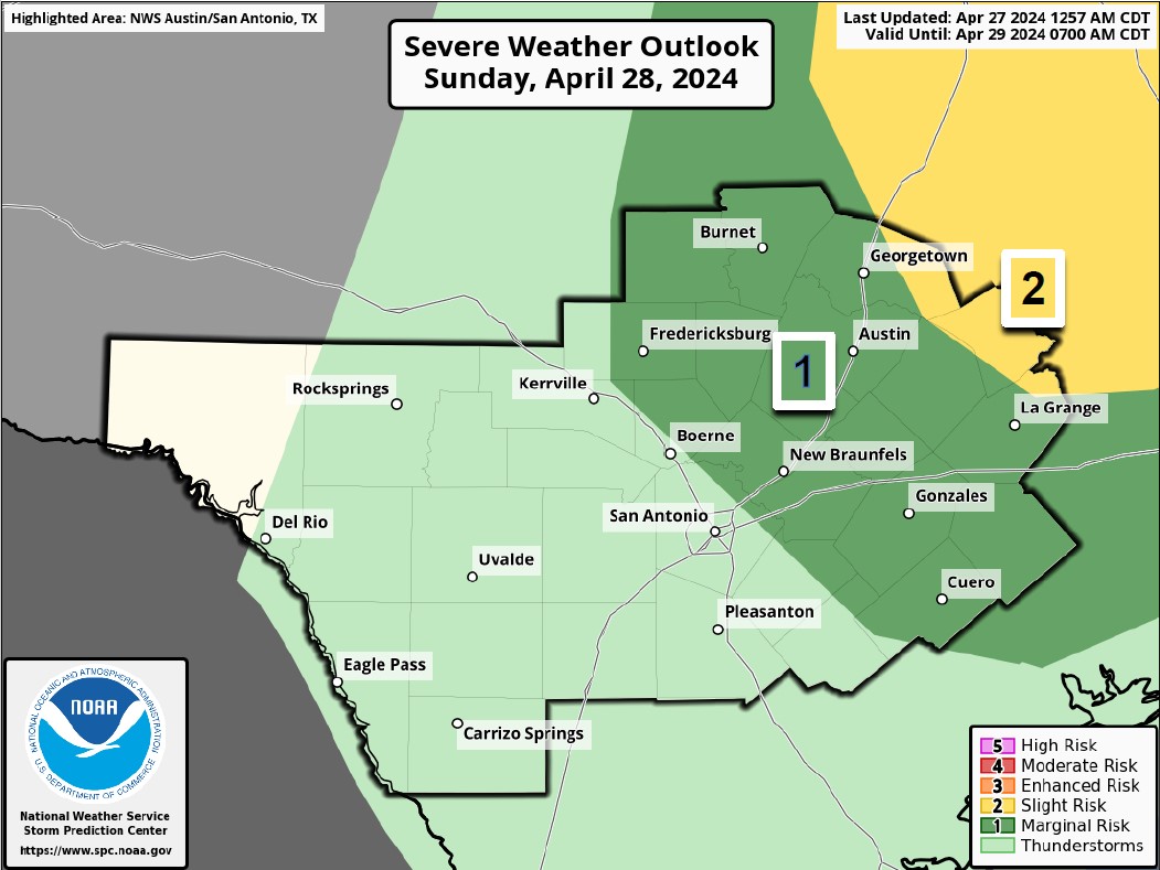
#BeWeatherAware: Severe thunderstorms possible late Sat night thru Sun, capable of large/very lrg hail, damaging wind, isolated tornadoes. Timing graphic was adjusted for later arrival, & level 2/5 risk introduced to far North portions of I35 corridor & Coastal Plains for Sunday.
account_circle