NWS New Orleans(@NWSNewOrleans) 's Twitter Profileg
NWS New Orleans

@NWSNewOrleans

Official Twitter account for the National Weather Service New Orleans. Details: https://t.co/iCJUV7vGsN

ID:594736235

linkhttp://www.weather.gov/neworleans calendar_today30-05-2012 16:53:52

40,5K Tweets

73,0K Followers

301 Following

Follow People
NWS New Orleans(@NWSNewOrleans) 's Twitter Profile Photo

Mostly cloudy skies will continue over the area into tomorrow but temperatures will still climb into the 80s both days. Overnight, lows will drop into the mid 60s north and near 70 south. The next chance of rainfall looks to be over the weekend, primarily on Sunday.

Mostly cloudy skies will continue over the area into tomorrow but temperatures will still climb into the 80s both days. Overnight, lows will drop into the mid 60s north and near 70 south. The next chance of rainfall looks to be over the weekend, primarily on Sunday. #lawx #mswx
account_circle
NWS New Orleans(@NWSNewOrleans) 's Twitter Profile Photo

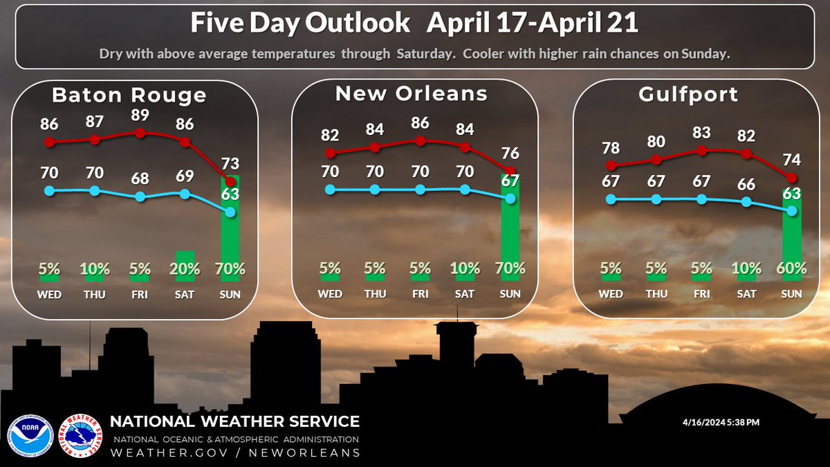
Warm and dry weather will continue through Saturday, but a front will bring higher rain chances and cooler temperatures to the area on Sunday.

Warm and dry weather will continue through Saturday, but a front will bring higher rain chances and cooler temperatures to the area on Sunday. #lawx #mswx
account_circle
NWS New Orleans(@NWSNewOrleans) 's Twitter Profile Photo

We are warmed up out there! Temperatures sitting around or at there high temps that were expected for today. Tomorrow we can expect similar conditions, with maybe a few more clouds than today.

We are warmed up out there! Temperatures sitting around or at there high temps that were expected for today. Tomorrow we can expect similar conditions, with maybe a few more clouds than today. #lawx #mswx
account_circle
NOAA Satellites(@NOAASatellites) 's Twitter Profile Photo

This , check out this 10+ hour loop via NOAA's ๐Ÿ›ฐ๏ธ from yesterday.

Here, a large amount of dust from the Saharan Desert is being swept gracefully up into a low pressure system over the Atlantic. What a beautiful dance!

account_circle
NWS New Orleans(@NWSNewOrleans) 's Twitter Profile Photo

Temperatures will remain warm today and into tomorrow, with highs both days in most areas in the low to mid 80s. Tonight, temperatures will drop into the upper 60s to lower 70s across the area. No rain chances are expected through tomorrow.

Temperatures will remain warm today and into tomorrow, with highs both days in most areas in the low to mid 80s. Tonight, temperatures will drop into the upper 60s to lower 70s across the area. No rain chances are expected through tomorrow. #lawx #mswx
account_circle
NWS New Orleans(@NWSNewOrleans) 's Twitter Profile Photo

Here is a look at the 3-Day Forecast. Generally, cloudy and warm this week! Highs will be in the low 80s for most of the area with lows in the upper 60s!

Here is a look at the 3-Day Forecast. Generally, cloudy and warm this week! Highs will be in the low 80s for most of the area with lows in the upper 60s!
account_circle
NWS New Orleans(@NWSNewOrleans) 's Twitter Profile Photo

Did you know that we have a new hydrology page to find river forecast information and more!? Check out our StoryMap that highlights some of the new changes and updated features! storymaps.arcgis.com/stories/fce72eโ€ฆ

account_circle
NWS New Orleans(@NWSNewOrleans) 's Twitter Profile Photo

Mostly Sunny to maybe partly cloudy. Warming into the 80s today for most of the area outside the immediate MS Gulf Coast.

Mostly Sunny to maybe partly cloudy. Warming into the 80s today for most of the area outside the immediate MS Gulf Coast. #lawx #mswx
account_circle
NWS New Orleans(@NWSNewOrleans) 's Twitter Profile Photo

We had a lot this week weather-wise, so we didn't talk much about the eclipse. It was obscured by clouds for the most part in our area (we are still disappointed lol). But this satellite gif shows the satellite perspective of the eclipse as it moved across the US. Very neat!

account_circle
NWS New Orleans(@NWSNewOrleans) 's Twitter Profile Photo

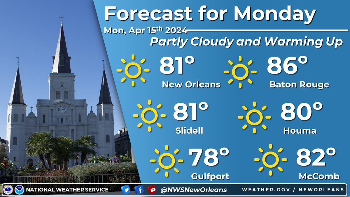
Mostly sunny to partly cloudy conditions across the region to start the new workweek. Temperatures appear to be around or slightly above average.

Mostly sunny to partly cloudy conditions across the region to start the new workweek. Temperatures appear to be around or slightly above average.
account_circle
NWS New Orleans(@NWSNewOrleans) 's Twitter Profile Photo

Here's a quick look at the week ahead:
โ˜€๏ธ Plenty of sunshine and beautiful weather to start the week.

โ›…๏ธ Clouds increase as moisture returns on Tuesday with mostly cloudy skies most likely on Wednesday.

๐ŸŒฆ๏ธ Slight increase to rain chances by Friday ahead of the next cold front.

Here's a quick look at the week ahead: โ˜€๏ธ Plenty of sunshine and beautiful weather to start the week. โ›…๏ธ Clouds increase as moisture returns on Tuesday with mostly cloudy skies most likely on Wednesday. ๐ŸŒฆ๏ธ Slight increase to rain chances by Friday ahead of the next cold front.
account_circle
NWS New Orleans(@NWSNewOrleans) 's Twitter Profile Photo

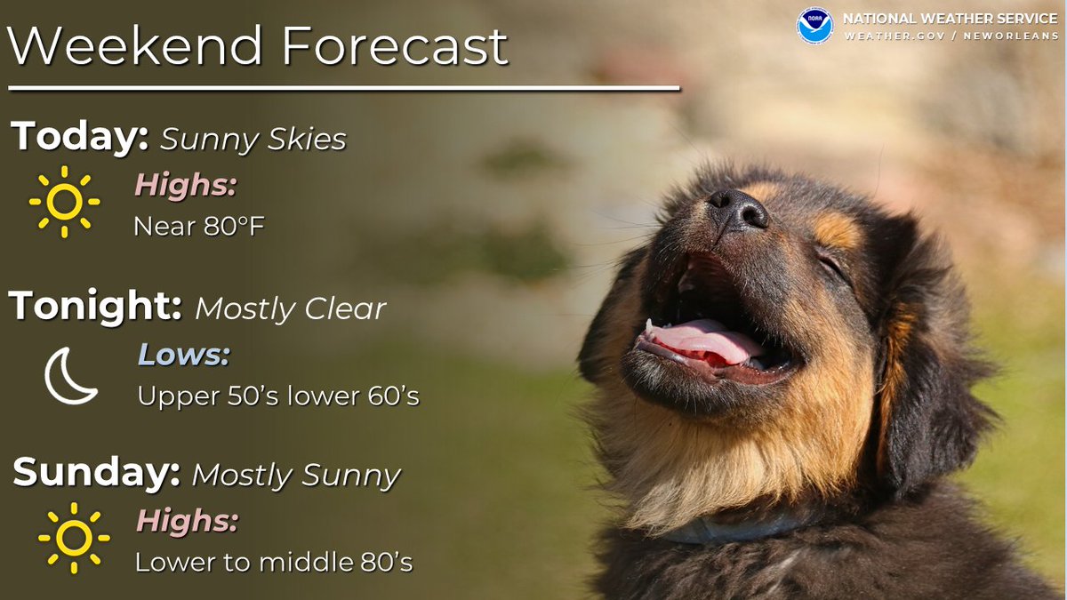
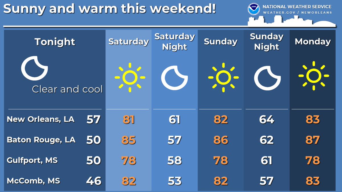
Clear skies, warm days, and pleasantly cool nights are on tap through the weekend. The weather will be perfect for any outdoor plans you have all weekend long.

Clear skies, warm days, and pleasantly cool nights are on tap through the weekend. The weather will be perfect for any outdoor plans you have all weekend long. #lawx #mswx
account_circle
NWS New Orleans(@NWSNewOrleans) 's Twitter Profile Photo

For clarification, the ground surveys themselves are complete, but we are still analyzing data from some areas. Additional updates are likely.

account_circle
NWS New Orleans(@NWSNewOrleans) 's Twitter Profile Photo

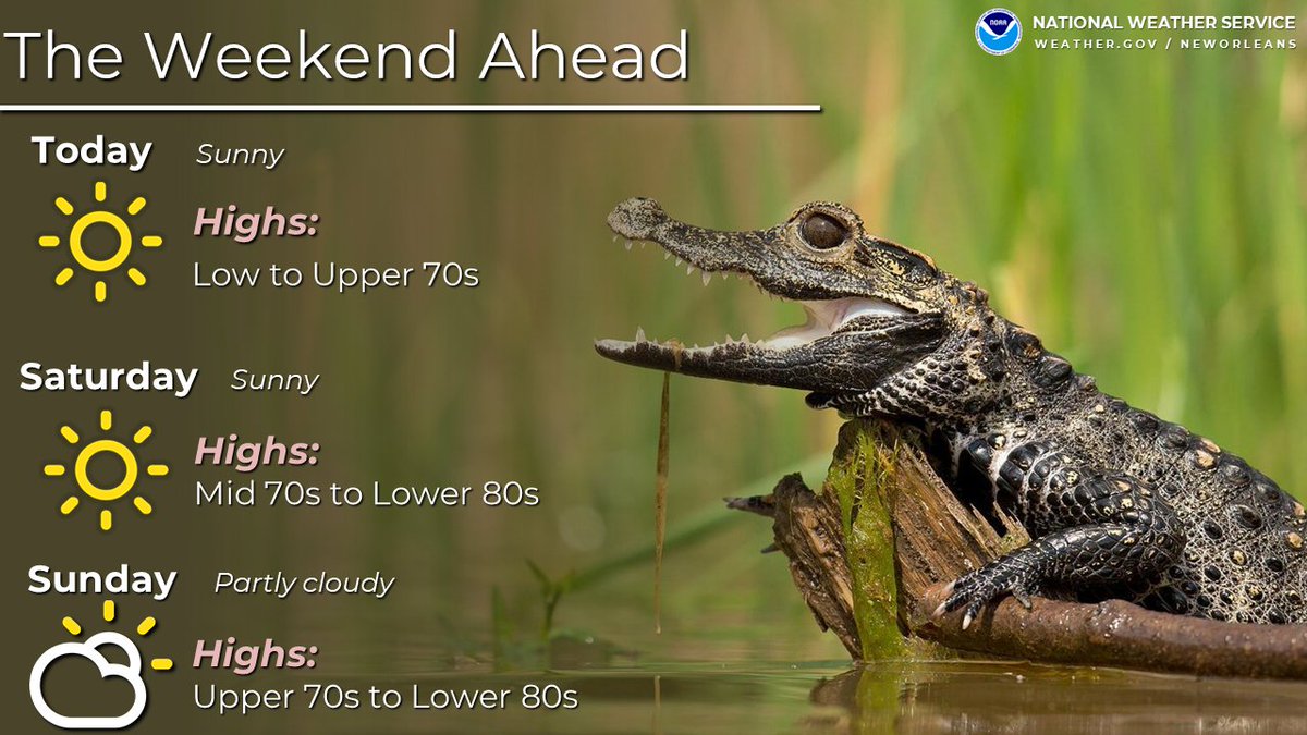
Quieter and slowly warming weather is on tap for today through this weekend with high temperatures in the 70s today and 70s/80s this weekend.

Quieter and slowly warming weather is on tap for today through this weekend with high temperatures in the 70s today and 70s/80s this weekend. #LAwx #MSwx
account_circle
NWS New Orleans(@NWSNewOrleans) 's Twitter Profile Photo

NWS Survey Crews in Saint Francisville report damage north of town consistent with at least an EF-1 tornado. The survey is ongoing at the time of this statement and should conclude later this evening with assessments in path length, path width and wind speeds forthcoming.

account_circle
NWS New Orleans(@NWSNewOrleans) 's Twitter Profile Photo

NWS Survey Crews in Slidell, LA report damage near Old Spanish Trail consistent with at least an EF-1 tornado. Additional surveys will be needed tomorrow (April 11, 2024) to assess path length, path width and max wind speeds.

account_circle