[1/2]
Some nice sand #dune s in eastern #SaudiArabia .
Enhanced visible light image taken by Copernicus EU #Sentinel2 on April 7, 2024.
Data processed in Sentinel Hub
#dune #desert #MiddleEast
![kosmi 🛰️🌍 (@kosmi64833127) on Twitter photo 2024-04-28 14:52:06 [1/2]
Some nice sand #dunes in eastern #SaudiArabia.
Enhanced visible light image taken by @CopernicusEU #Sentinel2 on April 7, 2024.
Data processed in @sentinel_hub
#dune #desert #MiddleEast [1/2]
Some nice sand #dunes in eastern #SaudiArabia.
Enhanced visible light image taken by @CopernicusEU #Sentinel2 on April 7, 2024.
Data processed in @sentinel_hub
#dune #desert #MiddleEast](https://pbs.twimg.com/media/GMQo7kSWgAEbgBa.jpg)

[1/2]
Today's view of #Sundhnúkur eruption in #Reykjanes Peninsula.
Image taken by @copernicusEU #Sentinel2 .
Data processed in Sentinel Hub
CultureVolcan Volcaholic 🌋
#Iceland #volcano
![kosmi 🛰️🌍 (@kosmi64833127) on Twitter photo 2024-05-01 18:21:22 [1/2]
Today's view of #Sundhnúkur eruption in #Reykjanes Peninsula.
Image taken by @copernicusEU #Sentinel2.
Data processed in @sentinel_hub
@CultureVolcan @volcaholic1
#Iceland #volcano [1/2]
Today's view of #Sundhnúkur eruption in #Reykjanes Peninsula.
Image taken by @copernicusEU #Sentinel2.
Data processed in @sentinel_hub
@CultureVolcan @volcaholic1
#Iceland #volcano](https://pbs.twimg.com/media/GMg1p5vW8AAVDJL.jpg)

#Ruang #volcano before & after the eruption
Take a closely view on the summit crater
📸🛰 #Sentinel1 delivered beautiful shots for a comparison
Footage: Copernicus EU Sentinel Hub
Global Volcanism Program h/t CultureVolcan

Today's view of #Sundhnúkur eruption in #Reykjanes Peninsula.
Lava continue to flow south along one of defensive walls protecting #Grindavik .
IR image taken by Copernicus EU #Sentinel2 .
Data processed in Sentinel Hub
CultureVolcan Volcaholic 🌋
#Iceland #volcano


🌷Tulips bloom in the Netherlands, Noordoostpolder, 30/4/24. Copernicus EU
copernicus.eu/en/media/image…


SWIFTT will use Copernicus EU Sentinel SAR data and powerful machine-learning models to provide foresters with maps of windthrow damage after a storm for post-storm forest management. Learn more: linkedin.com/feed/update/ur…


Have you ever heard of European Space Agency's World Fire Atlas?
The dashboard uses night-time data from Copernicus EU #Sentinel3 radiometer.
The sensor measures thermal infrared radiation to take the 🌡️ of Earth's land which is used to detect 🔥: s3wfa.esa.int

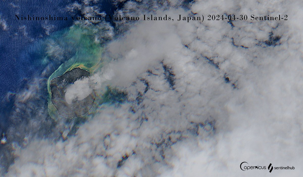
Discolored water around #Nishinoshima volcano! 🇯🇵
🌋VolcanoDiscovery activity update:
👉lnkd.in/gMaK_s9a
European Space Agency ESA Earth Observation Copernicus EU Sentinel Hub Sinergise Planet Pierre Markuse Global Volcanism Program


[1/2]
Increased activity at the Karan dome of #Shiveluch #volcano .
Images taken by Copernicus EU #Sentinel2 on April 28, 2024.
Data processed in Sentinel Hub
h/t Volcaholic 🌋 😉👍
#Kamchatka #Russia
![kosmi 🛰️🌍 (@kosmi64833127) on Twitter photo 2024-05-01 11:37:25 [1/2]
Increased activity at the Karan dome of #Shiveluch #volcano.
Images taken by @CopernicusEU #Sentinel2 on April 28, 2024.
Data processed in @sentinel_hub
h/t @volcaholic1 😉👍
#Kamchatka #Russia [1/2]
Increased activity at the Karan dome of #Shiveluch #volcano.
Images taken by @CopernicusEU #Sentinel2 on April 28, 2024.
Data processed in @sentinel_hub
h/t @volcaholic1 😉👍
#Kamchatka #Russia](https://pbs.twimg.com/media/GMfZODYWoAA-xix.jpg)

Follow the #Dust 2024.04.24-25
📸🛰 #Sentinel2 , #Sentinel3 , #Himawari9
Footage: Copernicus EU Sentinel Hub 気象庁防災情報

Image taken yesterday by Copernicus EU #Sentinel2 shows that one week after heavy rainfall in #Dubai the water is still there.
#UAE #MiddleEast #rain #flood
twitter.com/kosmi64833127/…


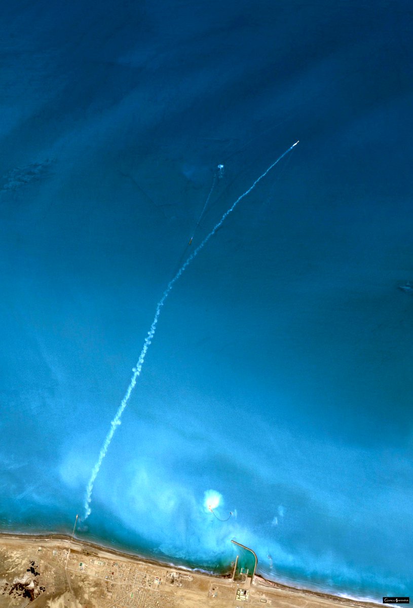
It's not the launch of space shuttle ☺️🚀
Small part of The #CaspianSea as seen by Copernicus EU #Sentinel2 on April 29, 2023.
Data processed in Sentinel Hub
#lake


Small part of The #CaspianSea .
Image taken by Copernicus EU #Sentinel2 on April 19, 2023.
Data processed in Sentinel Hub
#lake


Mt. St. #Helens volcano #USA
📸🛰 #Sentinel2 Timelapse 2016-2024 April only
3D in EO-Browser
Footage:Copernicus EU Sentinel Hub

#Sundhnúkur #Reykjanes #Iceland
Ongoing eruption
📸🛰 #Sentinel2 today 3D in EO-Browser
Footage: Copernicus EU Copernicus EU
Open in a new Tab ↔️↕️💯🔎


A part of Salina del Diamanté, #Argentina
Earth is an artist 👩🎨🎨
📸🛰 #Sentinel2
Footage: Copernicus EU Sentinel Hub


How dry is the Oldman Reservoir this spring compared with recent years? Western side with the inputs from the Castle, Crowsnest, and Oldman Rivers using normalized moisture index from Copernicus EU Sentinel-2 visualization from 2016 to now. Cool =wet, warm=dry


