Hrishi Jawahar(@jhrishi2) 's Twitter Profile Photo

UAC shown close to Gulf of Mannar in latest ECMWF 240 hrs output. Perfect setup for strong thunderstorms over the interior regions of , & as well!! This will ensure temp will be under check.

Hopefully this happens🤞

UAC shown close to Gulf of Mannar in latest ECMWF 240 hrs output. Perfect setup for strong thunderstorms over the interior regions of #Tamilnadu, #Kerala & #Karnataka as well!! This will ensure temp will be under check.

Hopefully this happens🤞

#Summer #Monsoon2024
account_circle
Parth(@Parth_GPT) 's Twitter Profile Photo

Observing a low-pressure system near Sri Lanka, drawing moisture from the Arabian Sea(+IOD?)

This could potentially fuel monsoon initially but delay the monsoon onset in Andaman & Nicobar Islands.

Observing a low-pressure system near Sri Lanka, drawing moisture from the Arabian Sea(+IOD?)

This could potentially fuel monsoon initially but delay the monsoon onset in Andaman & Nicobar Islands.
#Weather #Monsoon2024
account_circle
𝐃𝐫. 𝐏𝐫𝐚𝐝𝐞𝐞𝐩 𝐊𝐮𝐬𝐡𝐰𝐚𝐡𝐚(@pkusrain) 's Twitter Profile Photo

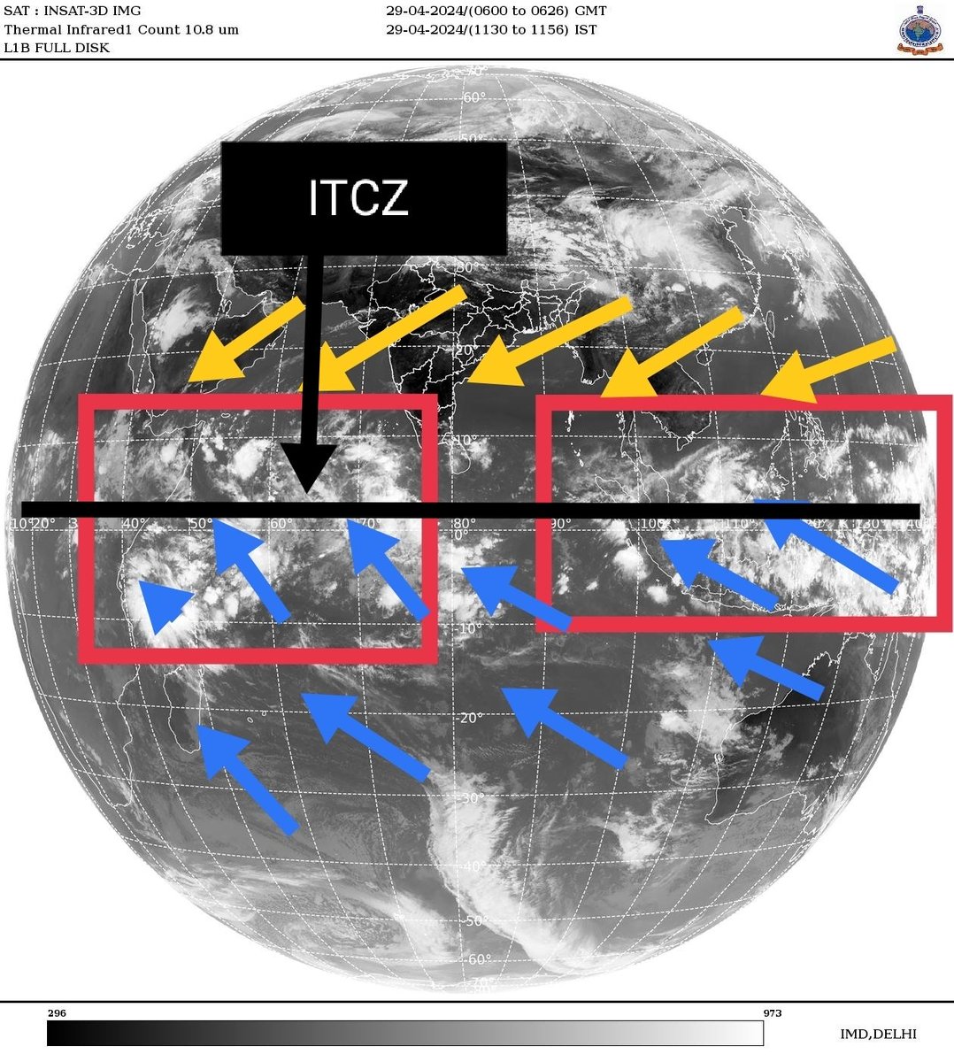
The Intertropical Convergence Zone (ITCZ) is progressively moving northwards and is currently situated just around the equator, triggering a lot of rain over the western equatorial Indian Ocean. We hope to see its further movement by the end of May.
Image : IMD

The Intertropical Convergence Zone (ITCZ) is progressively moving northwards and is currently situated just around the equator, triggering a lot of rain over the western equatorial Indian Ocean. We hope to see its further movement by the end of May. #monsoon2024
Image : IMD
account_circle
☔ Weatherforecaster (Sarath)(@_Imsarath2000) 's Twitter Profile Photo

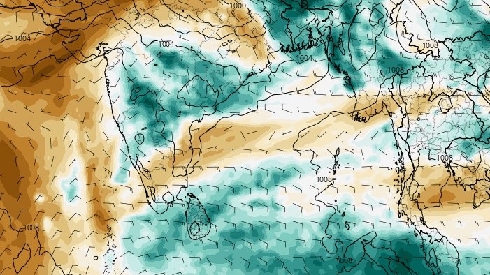
2024 onset over Andaman and Nicobar Islands between 15/20th
May.

Good inflow of winds bay of Bengal this time.Need to confirm if any monsoon system formation this period over bob.

#southwestmonsoon 2024 onset over Andaman and Nicobar Islands between 15/20th
May.

Good inflow of winds bay of Bengal this time.Need to confirm if any monsoon system formation this period over bob.
#monsoon2024
account_circle
Helmut Duerrast(@HelmutDuerrast) 's Twitter Profile Photo

30 Apr 24 07:10
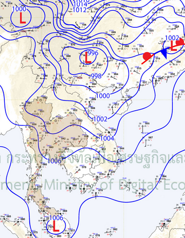
Weather and RAIN (blue-red-yellow=higher intensity) for & region; via zoom.earth, RAIN radar, map TMD.go.th
> Low NE
> Low Pressure - land (warmer)
> High Pressure (cooler) - further N
> STORMs over China

30 Apr 24 07:10
Weather and RAIN (blue-red-yellow=higher intensity) for #Thailand & region; via zoom.earth, RAIN radar, map TMD.go.th
> Low NE #monsoon2024
> Low Pressure - land (warmer)
> High Pressure (cooler) - further N 
> STORMs over China
account_circle
Hrishi Jawahar(@jhrishi2) 's Twitter Profile Photo

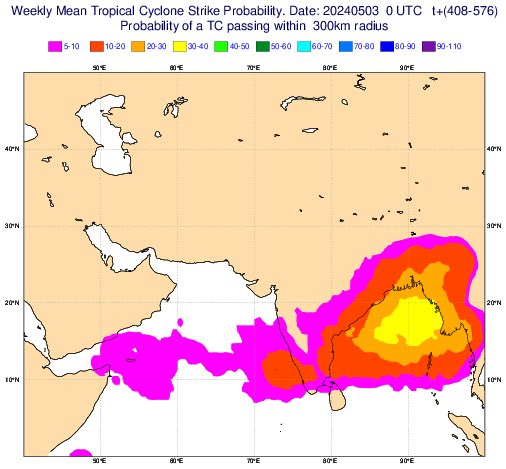
ECMWF weeklies showing a potential system in head Bay of Bengal at this time frame.. will be interesting to see how this pans out.

A pre-monsoon system probably in the coming weeks.

ECMWF

ECMWF weeklies showing a potential system in head Bay of Bengal at this time frame.. will be interesting to see how this pans out.

A pre-monsoon system probably in the coming weeks.

@ECMWF 

#Monsoon2024
account_circle
Pakistan Weather Times(@Weatherpk55) 's Twitter Profile Photo

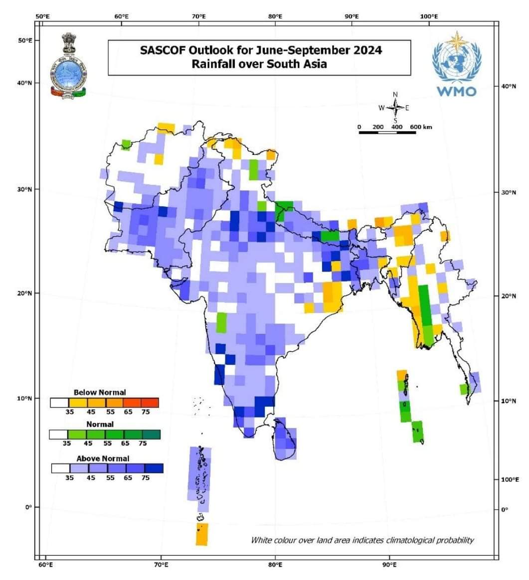
Above Normal Monsoon Rainfall in 2024 Pakistan india Bangladesh Nepal Bhutan SriLanka Maldives.
Karachi And Mumbai Ready For Extreme Heavy Downpour Rainfall in Monsoon Season June Till Sep.

Above Normal Monsoon Rainfall in 2024 Pakistan india Bangladesh Nepal Bhutan SriLanka Maldives.
Karachi And Mumbai Ready For Extreme Heavy Downpour Rainfall in Monsoon Season June Till Sep.
#Latest_News 
#Monsoon2024
account_circle
Athreya Shetty 🇮🇳(@shetty_athreya) 's Twitter Profile Photo

With just 2 weeks left until the 'Normal' onset date over south , let's get a progress check on shall we ?

1) Mascarene High (Monsoon Powerhouse) - Development below average (1026 mb), with a strong uniform HPA yet to organise over south Indian Ocean.

2)…

With just 2 weeks left until the 'Normal' onset date over south #Andaman, let's get a progress check on #Monsoon2024 shall we ?

1) Mascarene High (Monsoon Powerhouse) - Development below average (1026 mb), with a strong uniform HPA yet to organise over south Indian Ocean.

2)…
account_circle
☔ Weatherforecaster (Sarath)(@_Imsarath2000) 's Twitter Profile Photo

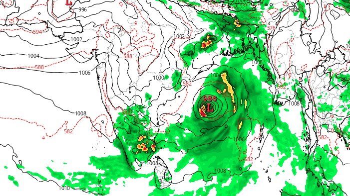
picking up potential pre-monsoon tropical cyclone over bay of Bengal during may mid week.
, see thunderstorm activity during this period starting May 6/7th.

#GFS picking up potential pre-monsoon tropical cyclone over bay of Bengal during may mid week. 
#kerala,#tamilnadu see thunderstorm activity during this period starting May 6/7th.
#cyclone #monsoon2024
account_circle