NWS Houston(@NWSHouston) 's Twitter Profile Photo

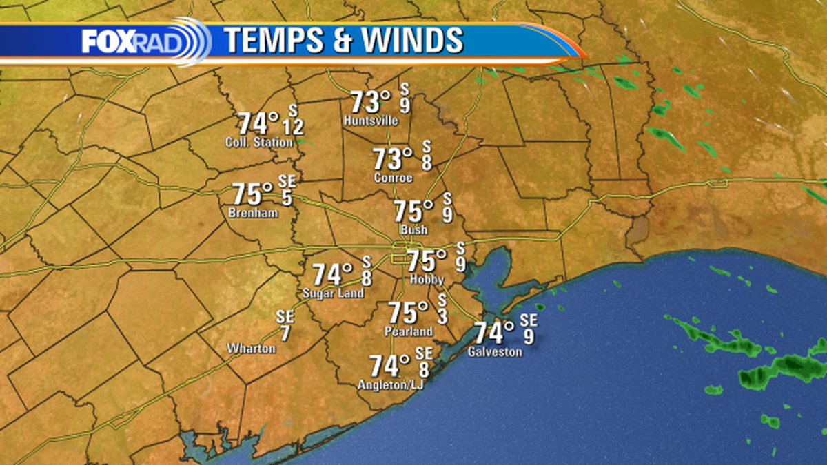
Temperatures today will reach near 90°F in some spots as the warming trend continues. 🌡️ A cold front approaches SE TX tonight, but stalls out just north of the area. Some scattered storms are possible around the Brazos Valley/Piney Woods overnight.

Temperatures today will reach near 90°F in some spots as the warming trend continues. 🌡️ A cold front approaches SE TX tonight, but stalls out just north of the area. Some scattered storms are possible around the Brazos Valley/Piney Woods overnight. #TXwx #HOUwx #BCSwx #GLSwx
account_circle
NWS Houston(@NWSHouston) 's Twitter Profile Photo

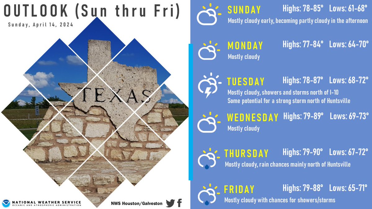
A gradual warming trend can be expected across much of SE TX over the next several days. Some spots could approach 90 degrees for highs on Wednesday and/or Thursday. Want it to get cooler again? Maybe next weekend.

A gradual warming trend can be expected across much of SE TX over the next several days. Some spots could approach 90 degrees for highs on Wednesday and/or Thursday. Want it to get cooler again?  Maybe next weekend. #txwx #houwx #glswx #bcswx
account_circle
NWS Houston(@NWSHouston) 's Twitter Profile Photo

Here are the expected weekend temeperatures (today's highs, tonight's low, Sunday's highs and Sunday night's lows) across SE TX. Look for gradually rising humidities due to increasing/strengthening south to southeast winds.

Here are the expected weekend temeperatures (today's highs, tonight's low, Sunday's highs and Sunday night's lows) across SE TX. Look for gradually rising humidities due to increasing/strengthening south to southeast winds. #txwx #houwx #glswx #bcswx
account_circle
NWS Houston(@NWSHouston) 's Twitter Profile Photo

Quiet, pleasant weather should continue across SE Texas into the beginning of next week. Lows tonight will be in the 60s to lower 70s. Highs on Monday will be in the mid/lower 80s inland and 70s near the coast.

Quiet, pleasant weather should continue across SE Texas into the beginning of next week. Lows tonight will be in the 60s to lower 70s. Highs on Monday will be in the mid/lower 80s inland and 70s near the coast. #TXwx #HOUwx
account_circle
NWS Houston(@NWSHouston) 's Twitter Profile Photo

The pleasant weather continues going into the weekend with high temperatures in the upper 70s/low 80s and gradually increasing overnight low temperatures from the 50s to the 60s. Rain chances are at zero for this weekend! 😎

The pleasant weather continues going into the weekend with high temperatures in the upper 70s/low 80s and gradually increasing overnight low temperatures from the 50s to the 60s. Rain chances are at zero for this weekend! 😎 #TXwx #HOUwx #BCSwx #GLSwx
account_circle
Billy Forney 3(@BillyForney3) 's Twitter Profile Photo

Severe thunderstorm west-southwest of Houston has radar-indicated cloud tops exceeding 55k feet! Plus, it has developed a hail core as it approaches Sealy from the South.

Severe thunderstorm west-southwest of Houston has radar-indicated cloud tops exceeding 55k feet! Plus, it has developed a hail core as it approaches Sealy from the South.

#houwx #txwx
account_circle
Billy Forney 3(@BillyForney3) 's Twitter Profile Photo

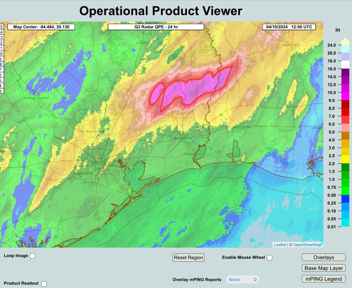
MRMS Radar estimates that total 24-hr storm accumulated rainfall in areas northeast of Houston, for example near Warren, Jasper, and Kirbyville, TX, exceeded 12” in some spots with a wide swath of 9”+ totals (red-outlined area).

MRMS Radar estimates that total 24-hr storm accumulated rainfall in areas northeast of Houston, for example near Warren, Jasper, and Kirbyville, TX, exceeded 12” in some spots with a wide swath of 9”+ totals (red-outlined area).

#txwx #houwx
account_circle
Radi K(@Radi_WX) 's Twitter Profile Photo

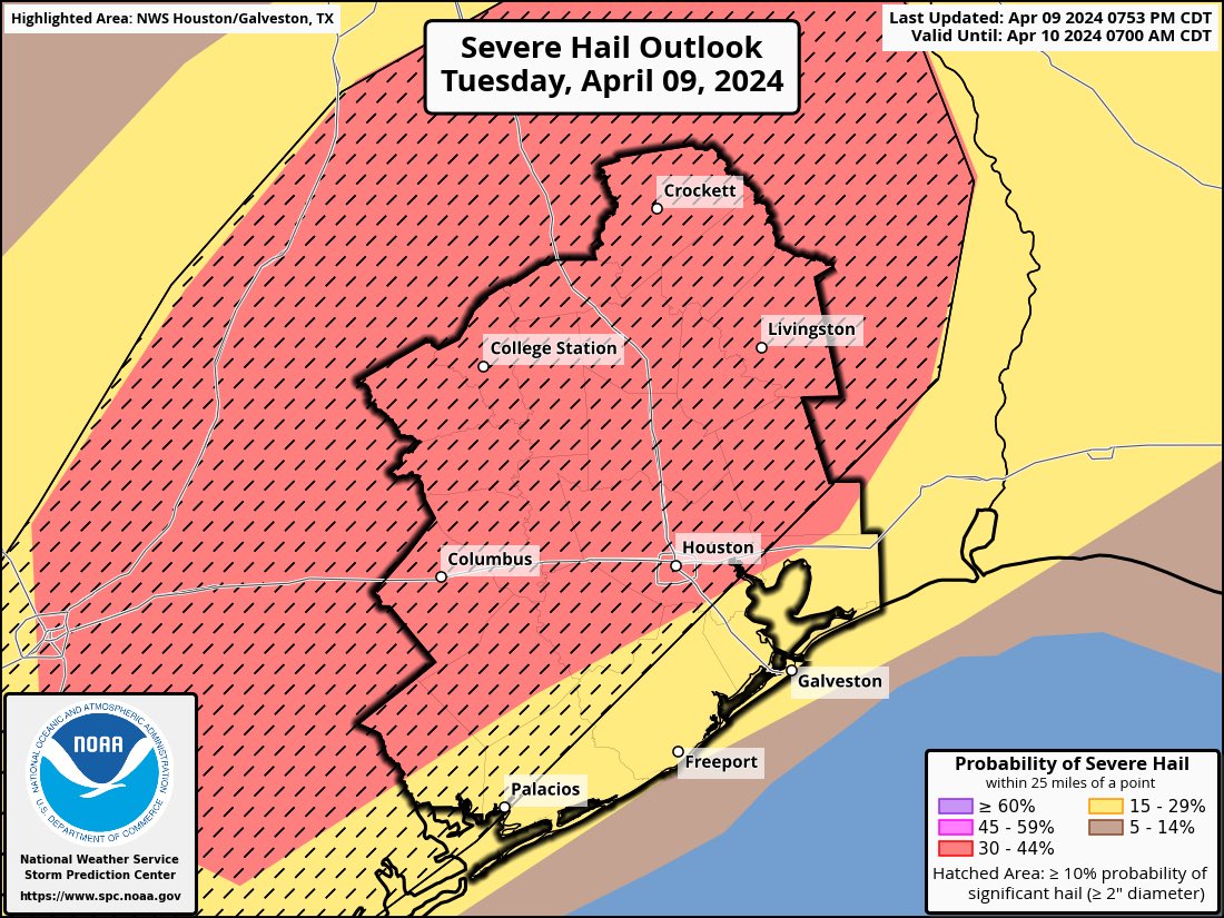
Enhanced risk shifted to majority of the Houston area with 10% tornado hatched and with hatched risk for damaging winds and hail. Tonight may be rough. Please have MULTIPLE ways to receive weather warnings.

Enhanced risk shifted to majority of the Houston area with 10% tornado hatched and with hatched risk for damaging winds and hail. Tonight may be rough. Please have MULTIPLE ways to receive weather warnings. #houwx #txwx #wx
account_circle
Radi K(@Radi_WX) 's Twitter Profile Photo

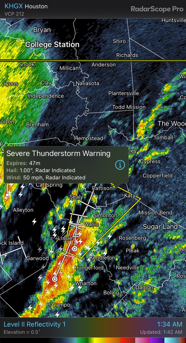
And speak of the devil… A Severe Thunderstorm Warning posted for the Katy area. This includes quarter size hail.

And speak of the devil… A Severe Thunderstorm Warning posted for the Katy area. This includes quarter size hail. #txwx #houwx
account_circle
NWS Houston(@NWSHouston) 's Twitter Profile Photo

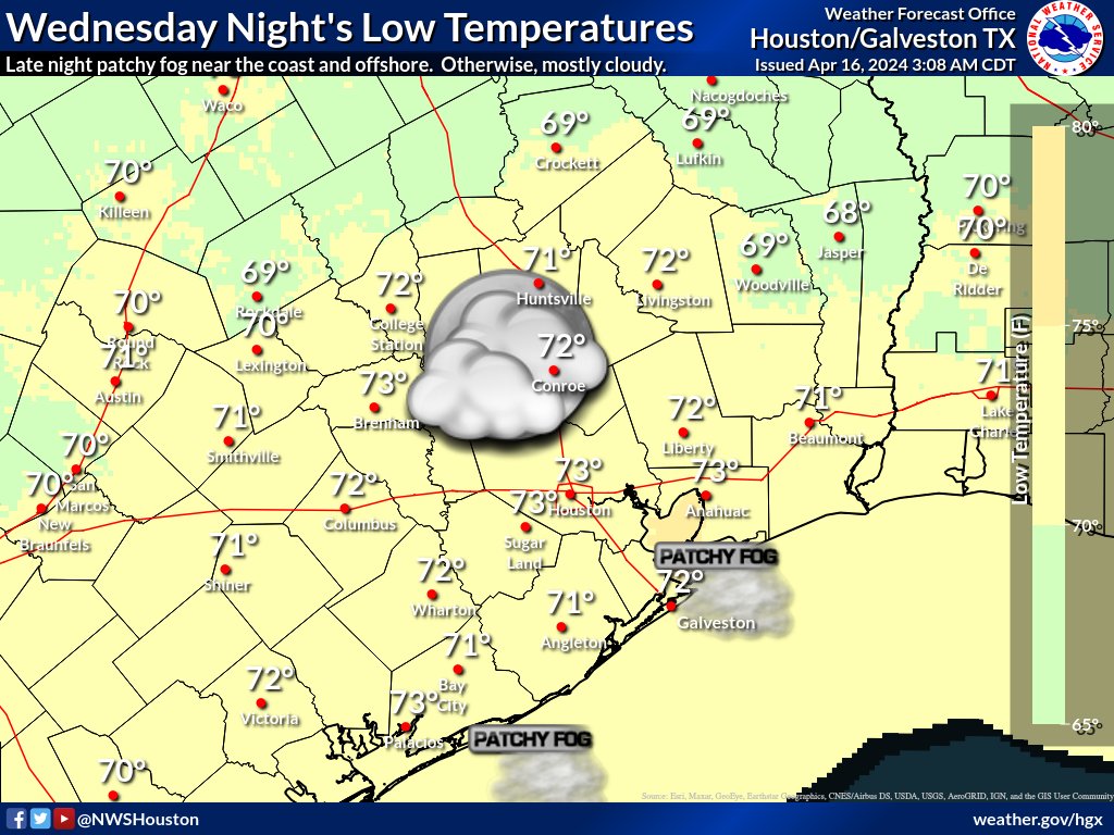
Here are the latest SE TX temp outlooks for today/ tonight/Wednesday/Wednesday night. Today: warm/breezy. Tonight: patchy fog possible late. Wednesday: patchy fog possible early. Wednesday night: late night patchy fog possible near the coast & offshore.

Here are the latest SE TX temp outlooks for today/ tonight/Wednesday/Wednesday night. Today: warm/breezy. Tonight: patchy fog possible late. Wednesday: patchy fog possible early. Wednesday night: late night patchy fog possible near the coast & offshore. #txwx #houwx #glswx #bcswx
account_circle