Andrew Labit(@AndrewLabitWX) 's Twitter Profile Photo

Are you looking to swing at a few golf balls? Well look no further as tomorrow will be a great day to get that 🦅! Summer like weather for Sunday, but don't forget about the wind. It might take your shot off course.

Are you looking to swing at a few golf balls? Well look no further as tomorrow will be a great day to get that 🦅! Summer like weather for Sunday, but don't forget about the wind. It might take your shot off course. #mowx #midmowx
account_circle
Sawyer Jackson(@SawyerJ_KMIZ17) 's Twitter Profile Photo

If you thought today was warm, just wait! Tomorrow we will warm into the upper 80s by the afternoon hours and threaten a record high temperature set on April 14th, 2006! This warmth sticks around until Monday night. Find out why here: abc17news.com/weather/2024/0…

If you thought today was warm, just wait! Tomorrow we will warm into the upper 80s by the afternoon hours and threaten a record high temperature set on April 14th, 2006! This warmth sticks around until Monday night. Find out why here: abc17news.com/weather/2024/0…
#midmowx #CoMo #JCMO
account_circle
Matt Beckwith(@KOMUMatt) 's Twitter Profile Photo

Eclipse Forecast: High and thin clouds are expected over southeastern parts of the state during the eclipse. If there's going to be clouds during an eclipse... this is the kind you want! Wx

Eclipse Forecast: High and thin clouds are expected over southeastern parts of the state during the eclipse. If there's going to be clouds during an eclipse... this is the kind you want! #MidMoWx #MoWx #MidMo
account_circle
NWS St. Louis(@NWSStLouis) 's Twitter Profile Photo

A combination of low relative humidity, gusty south winds, and dry fuels will cause an elevated fire danger this afternoon across parts of northeast and central Missouri as well as west central Illinois.

A combination of low relative humidity, gusty south winds, and dry fuels will cause an elevated fire danger this afternoon across parts of northeast and central Missouri as well as west central Illinois.  #mowx #stlwx #midmowx #ilwx
account_circle
NWS St. Louis(@NWSStLouis) 's Twitter Profile Photo

A big warmup is in store across the region starting Saturday! By early next week, high temperatures will approach records across the region. Get the latest forecast for your location at weather.gov/stlouis.

A big warmup is in store across the region starting Saturday! By early next week, high temperatures will approach records across the region. Get the latest forecast for your location at weather.gov/stlouis. #MOwx #ILwx #STLwx #MidMOwx
account_circle
NWS St. Louis(@NWSStLouis) 's Twitter Profile Photo

Showers and thunderstorms accompany an active weather pattern early next week. While the thunderstorms appear certain, how strong they will be remains unclear. Keep up to date with any forecast changes!

Showers and thunderstorms accompany an active weather pattern early next week. While the thunderstorms appear certain, how strong they will be remains unclear. Keep up to date with any forecast changes! #MOwx #ILwx #STLwx #MidMOwx
account_circle
NWS Springfield(@NWSSpringfield) 's Twitter Profile Photo

A warming trend will occur this weekend with temperatures well into the 80s by Sunday! Winds will be breezy which will lead to an elevated fire danger for locations that still have not greened up yet. No rain is expected this weekend.

A warming trend will occur this weekend with temperatures well into the 80s by Sunday! Winds will be breezy which will lead to an elevated fire danger for locations that still have not greened up yet. No rain is expected this weekend. #sgf #mowx #kswx #ozarkswx #midmowx
account_circle
NWS St. Louis(@NWSStLouis) 's Twitter Profile Photo

An unsettled weather pattern will bring several rounds of showers and scattered thunderstorms to the area this week. The greatest chance for rain will be over southeast Missouri and southwest Illinois.

An unsettled weather pattern will bring several rounds of showers and scattered thunderstorms to the area this week.  The greatest chance for rain will be over southeast Missouri and southwest Illinois. #stlwx #midmowx #mowx #ilwx
account_circle
Beth Finello(@BethFinelloWx) 's Twitter Profile Photo

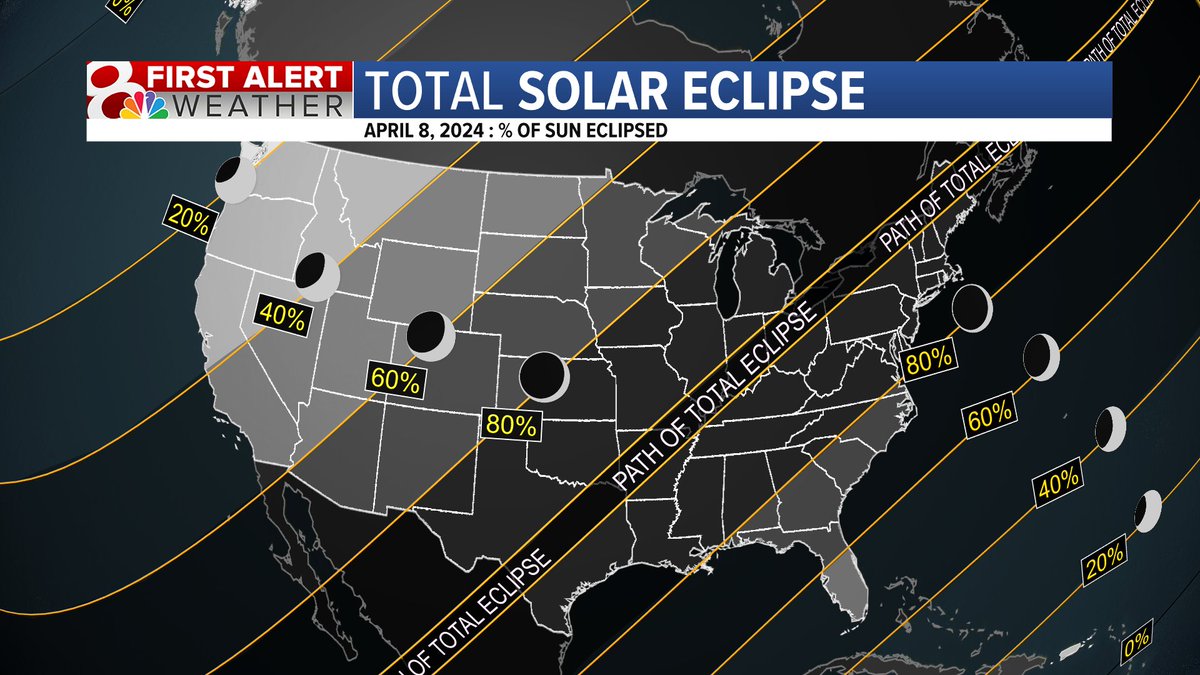
IT IS ECLIPSE DAY!! I'll be heading down to SEMO with Elly Laliberte & Dominick Lee! Viewing across Missouri looks great! Just a few high clouds, excited to see pictures and videos! KOMU 8 News wx

IT IS ECLIPSE DAY!! I'll be heading down to SEMO with @ellylalibertetv & @DomPhotog! Viewing across Missouri looks great! Just a few high clouds, excited to see pictures and videos! @KOMUnews #midmowx #midmo #mowx
account_circle
Kesley Kobielusz(@kesley_wx) 's Twitter Profile Photo

I saw a long line for the car wash this morning on my way in to work. If you didn't get the chance this morning, there is still plenty of time to get a car wash this weekend before rain chances next week🚗

wx

I saw a long line for the car wash this morning on my way in to work. If you didn't get the chance this morning, there is still plenty of time to get a car wash this weekend before rain chances next week🚗

#midmowx #midmo #Mowx
account_circle
Kesley Kobielusz(@kesley_wx) 's Twitter Profile Photo

Even though Columbia was not in the path of totality, we still saw a dramatic change of temperature! We went from 73 as the moon started to block the sun, and drop to 66 by our peak! Did you feel the temp change? I got a little chilly!

wx

Even though Columbia was not in the path of totality, we still saw a dramatic change of temperature! We went from 73 as the moon started to block the sun, and drop to 66 by our peak! Did you feel the temp change? I got a little chilly!

#midmowx #midmo #mowx
account_circle
NWS St. Louis(@NWSStLouis) 's Twitter Profile Photo

UPDATE: Elevated fire danger is now forecast across eastern and central Missouri and west-central Illinois this afternoon. Be careful with any open flames, and ensure you extinguish fires fully!

account_circle
NWS St. Louis(@NWSStLouis) 's Twitter Profile Photo

An unsettled weather pattern will bring showers and a few storms to the area through Thursday night. For a forecast for your location, go to weather.gov and type in your city.

An unsettled weather pattern will bring showers and a few storms to the area through Thursday night.  For a forecast for your location, go to weather.gov and type in your city. #stlwx #midmowx #mowx #ilwx
account_circle
NWS St. Louis(@NWSStLouis) 's Twitter Profile Photo

Not much has changed surrounding the potential for strong to severe storms, though it looks like Tuesday has the highest threat.

Keep up-to-date at weather.gov/stlouis - the forecast will change as more details become clear!

account_circle
Matt Beckwith(@KOMUMatt) 's Twitter Profile Photo

First Alert: It’s looking like an active start to the new work week! We’ll see chances of showers and a few thunderstorms Monday night with higher chances on Tuesday. A few storms could be strong to severe in this time frame. 1/2 Wx

First Alert: It’s looking like an active start to the new work week! We’ll see chances of showers and a few thunderstorms Monday night with higher chances on Tuesday. A few storms could be strong to severe in this time frame. 1/2 #MidMoWx #MoWx #MidMo
account_circle
NWS St. Louis(@NWSStLouis) 's Twitter Profile Photo

Showers and a few thunderstorms will spread across the area and continue through late Thursday. The greatest chance for rain and the heaviest amounts will be over southeast Missouri and southwest Illinois.

Showers and a few thunderstorms will spread across the area and continue through late Thursday. The greatest chance for rain and the heaviest amounts will be over southeast Missouri and southwest Illinois. #stlwx #midmowx #mowx #ilwx
account_circle
NWS St. Louis(@NWSStLouis) 's Twitter Profile Photo

Rain chances increase across most of the region tomorrow through mid-week. Especially for those along and south of I-44, beneficial rain will fall. For a detailed, location-specific forecast, head to weather.gov/stlouis.

Rain chances increase across most of the region tomorrow through mid-week. Especially for those along and south of I-44, beneficial rain will fall. For a detailed, location-specific forecast, head to weather.gov/stlouis. #MOwx #ILwx #STLwx #MidMOwx
account_circle