Transit Maps(@transitmap) 's Twitter Profileg
Transit Maps

@transitmap

A celebration of transit maps and diagrams from around the world.
RTs are always appreciated!

Prints for sale at: https://t.co/AB64kOlrCG

ID:400292974

linkhttps://www.transitmap.net/ calendar_today28-10-2011 20:07:05

14,8K Tweets

23,5K Followers

464 Following

Transit Maps(@transitmap) 's Twitter Profile Photo

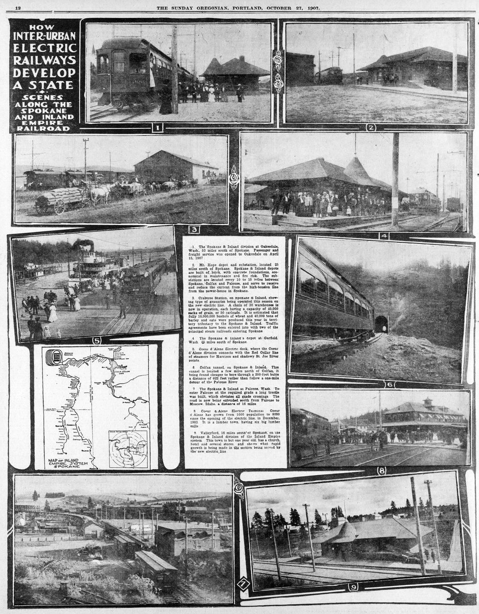
Fantastic little photo essay on the Spokane & Inland Empire (electric interurban) Railroad in 'The Oregonian', October 27, 1907. If you look closely, you can see that the 'Inland Empire System' logo on the map echoes the track layout at the railroad's Spokane terminal. Neat!

Fantastic little photo essay on the Spokane & Inland Empire (electric interurban) Railroad in 'The Oregonian', October 27, 1907. If you look closely, you can see that the 'Inland Empire System' logo on the map echoes the track layout at the railroad's Spokane terminal. Neat!
account_circle
Transit Maps(@transitmap) 's Twitter Profile Photo

And a bit of future-proofing while I'm here: Oklahoma City now lines up vertically with Newton so that the future Heartland Flyer extension can just slot right in.

And a bit of future-proofing while I'm here: Oklahoma City now lines up vertically with Newton so that the future Heartland Flyer extension can just slot right in.
account_circle
Transit Maps(@transitmap) 's Twitter Profile Photo

An interesting approach! And here's what the Borealis looks like on my Amtrak-as-Subway-Diagram... yep, that's 16 [sixteen!] routes into/out of Chicago now!

An interesting approach! And here's what the Borealis looks like on my Amtrak-as-Subway-Diagram... yep, that's 16 [sixteen!] routes into/out of Chicago now!
account_circle
Transit Maps(@transitmap) 's Twitter Profile Photo

And a bit of future-proofing while I'm here: Oklahoma City now lines up vertically with Newton so that the future Heartland Flyer extension can just slot right in.

And a bit of future-proofing while I'm here: Oklahoma City now lines up vertically with Newton so that the future Heartland Flyer extension can just slot right in.
account_circle
Transit Maps(@transitmap) 's Twitter Profile Photo

An interesting approach! And here's what the Borealis looks like on my Amtrak-as-Subway-Diagram... yep, that's 16 [sixteen!] routes into/out of Chicago now!

An interesting approach! And here's what the Borealis looks like on my Amtrak-as-Subway-Diagram... yep, that's 16 [sixteen!] routes into/out of Chicago now!
account_circle
William Hazen(@WilliamHazen7) 's Twitter Profile Photo

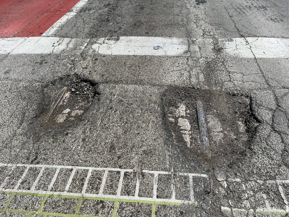
The potholes have gotten so deep at Washington and Illinois you can now see both tracks for the old E Washington Streetcar line!

The potholes have gotten so deep at Washington and Illinois you can now see both tracks for the old E Washington Streetcar line!
account_circle
Transit Maps(@transitmap) 's Twitter Profile Photo

It's Amtrak's birthday, so here's my map of what national passenger rail service looked like back in May, 1971: transitmap.net/amtrak-may-197…

account_circle
Transit Maps(@transitmap) 's Twitter Profile Photo

I know TriMet is proud of their 'Better Red' program, but showing the old loop and new inbound overpass at Gateway on the map just seems overly-fussy. 'Gateway North' should just be part of Gateway TC on the map with signs directing riders to/from the platform in real life.

account_circle
Transit Maps(@transitmap) 's Twitter Profile Photo

It's Amtrak's birthday, so here's my map of what national passenger rail service looked like back in May, 1971: transitmap.net/amtrak-may-197…

account_circle
Transit Maps(@transitmap) 's Twitter Profile Photo

I know TriMet is proud of their 'Better Red' program, but showing the old loop and new inbound overpass at Gateway on the map just seems overly-fussy. 'Gateway North' should just be part of Gateway TC on the map with signs directing riders to/from the platform in real life.

account_circle
Mike.Ashworth(@Mikeashworth12) 's Twitter Profile Photo

The diagram in the booklet shows the proposed extensions north of the river through the City to Beckton and Thamesmead - plans radically changed over the next decade. Mark Ovenden Transit Maps

The diagram in the booklet shows the proposed extensions north of the river through the City to Beckton and Thamesmead - plans radically changed over the next decade. #Underground @markovenden @transitmap
account_circle
Transit Maps(@transitmap) 's Twitter Profile Photo

Reading the National Register of Historic Places application for the Sellwood Carmen's Clubhouse and I like this statement:
'The optimistic days of the interurbans began to wane after 1912. No single factor was responsible for the decline of this service.'
Simple and concise.

Reading the National Register of Historic Places application for the Sellwood Carmen's Clubhouse and I like this statement: 'The optimistic days of the interurbans began to wane after 1912. No single factor was responsible for the decline of this service.' Simple and concise.
account_circle
Transit Maps(@transitmap) 's Twitter Profile Photo

Ray Delahanty | CityNerd polythene sam Montavilla provides my fave Portland streetcar fact: the full name of the tract – Mount Tabor Villa – wouldn’t fit on the headboard of the cars, so they contracted it to “Moun-Ta-Villa”, then “Montavilla”. The abbreviated name caught on, and is what we use to this day.

account_circle
Ray Delahanty | CityNerd(@Nerd4Cities) 's Twitter Profile Photo

You can buy prints of this one (and tons of other great stuff) on his site. Check it out if you aren’t familiar!

transitmap.net/project-street…

account_circle
Transit Maps(@transitmap) 's Twitter Profile Photo

Hey! You should all check out this Ray Delahanty | CityNerd video where he uses my map of Portland's streetcars in 1915 to take you on a virtual tour of the 'streetcar neighborhoods' that are such an amazing part of the fabric of this city. Well worth a watch!

youtube.com/watch?v=W6uy6S…

account_circle
Ray Delahanty | CityNerd(@Nerd4Cities) 's Twitter Profile Photo

Huge thanks to Transit Maps for use of this modern recreation of the 1915 electric railway map for Portland, OR in today’s video. He does such amazing stuff!
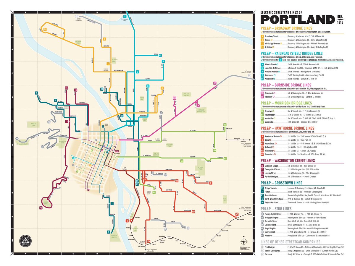
Huge thanks to @transitmap for use of this modern recreation of the 1915 electric railway map for Portland, OR in today’s video. He does such amazing stuff!
account_circle
Neil Renic(@NC_Renic) 's Twitter Profile Photo

Me: 'I'd like to copy and paste from this pdf please'

Adobe Acrobat: 'no worries, I took the liberty of stacking each word on top of each other in a vertical column, adding mysterious symbols, and removing every instance of the letter 't''

account_circle