Rob Mayeda(@RobMayeda) 's Twitter Profileg
Rob Mayeda

@RobMayeda

Bay Area AMS Meteorologist since 2003 CSU/SJSU Lecturer. Formerly KIRO, KCRA, KSBY, KESQ, KNBC, Arizona Daily Wildcat & dad of twinados 👦🏻🌪️👦🏻🌪️

ID:22802715

linkhttp://www.nbcbayarea.com calendar_today04-03-2009 17:22:55

75,5K Tweets

31,0K Followers

9,9K Following

Follow People
Rob Mayeda(@RobMayeda) 's Twitter Profile Photo

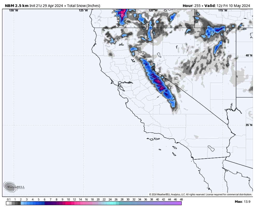
If you’re a fan of 70s and inland 80s enjoy the next two days… the weekend will be much cooler, breezy, and the consensus is building rainy to start as well. Note wintry travel for the Sierra too. Euro joining the GFS line of thinking w/ regard to Saturday. Stay tuned

account_circle
Chris Vagasky ⚡️(@COweatherman) 's Twitter Profile Photo

Looks like Gunung Ruang has been undergoing a significant eruption since about 1840 UTC, with a much more lightning-filled plume than the one a couple weeks ago.

Over 16,000 lightning events detected in the Ruang plume since 1841 UTC.

account_circle
CIRA(@CIRA_CSU) 's Twitter Profile Photo

The Ruang volcano has erupted once again.

Himawari-9 captured the moment of the explosive eruption, releasing a cloud of ash and sulfur dioxide into the atmosphere.

account_circle
NASA(@NASA) 's Twitter Profile Photo

NASA Webb Telescope isn’t foaling around with its level of detail! 🐴

Just recently, Webb captured the sharpest infrared images of the Horsehead Nebula to date. Learn more photos and see comparisons: go.nasa.gov/3Uy7wEW
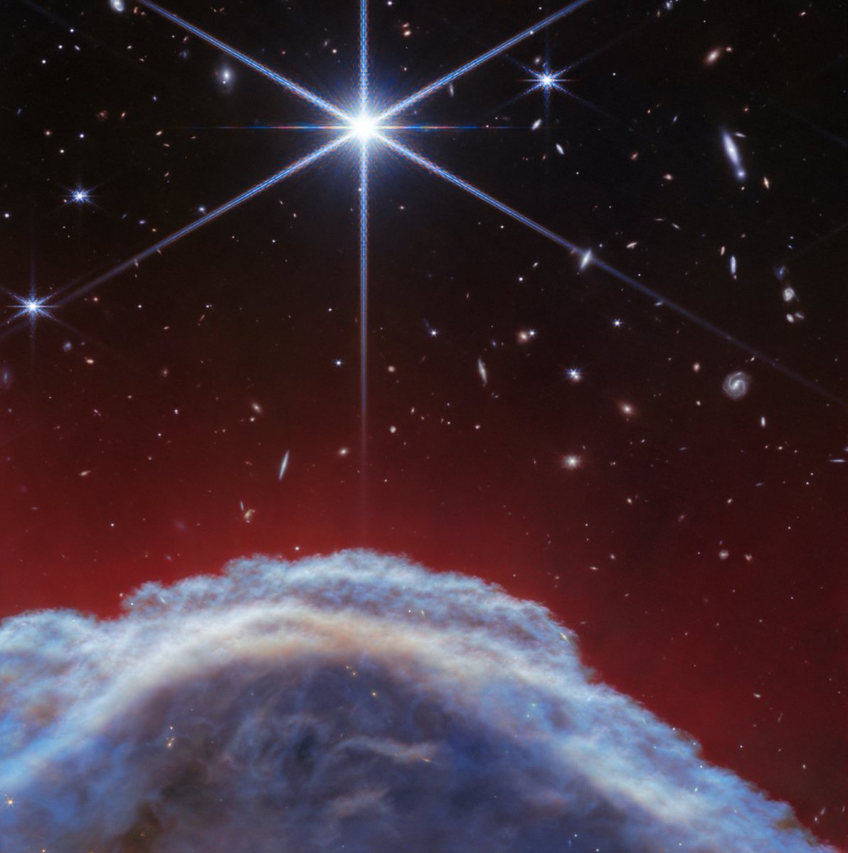
@NASAWebb isn’t foaling around with its level of detail! 🐴 Just recently, Webb captured the sharpest infrared images of the Horsehead Nebula to date. Learn more photos and see comparisons: go.nasa.gov/3Uy7wEW
account_circle
Rob Mayeda(@RobMayeda) 's Twitter Profile Photo

Windy & warming: wind advisories hoisted for interior Northern California including Solano County 11pm Tuesday to 5pm Wednesday. Dry gusty north / offshore wind will usher in warming temps midweek. 4/29/2024

account_circle
Rob Mayeda(@RobMayeda) 's Twitter Profile Photo

Reservoir levels are looking solid wrapping up April 2024. (2023, 2022 shown for reference). Snowmelt season starting to boost some totals moving forward into May, plus those ongoing high elevation snow (and rain below) chances as well ahead. 4/29/2024

Reservoir levels are looking solid wrapping up April 2024. (2023, 2022 shown for reference). Snowmelt season starting to boost some totals moving forward into May, plus those ongoing high elevation snow (and rain below) chances as well ahead. #CAwx 4/29/2024
account_circle
Rob Mayeda(@RobMayeda) 's Twitter Profile Photo

Decent warmup on the way Tuesday-Thursday...then the weekend forecast will be breezy and much cooler. After that? The Euro/GFS currently in disagreement mode. Ensembles do at least look showery though Sat-Sun based on current trends. Stay tuned... 4/29/2024

Decent warmup on the way Tuesday-Thursday...then the weekend forecast will be breezy and much cooler. After that? The Euro/GFS currently in disagreement mode. Ensembles do at least look showery though Sat-Sun based on current trends. Stay tuned... #CAwx 4/29/2024
account_circle
Doppler on Wheels (DOW)(@DOWFacility) 's Twitter Profile Photo

Preliminary Wind Summary Measurements and Analysis from Harlan, IA tornado on Friday (26 April 2024).
Winds of ~224 mph and diameter of max winds of ~2966 ft.
Observations were taken as part of the U.S. National Science Foundation -sponsored project led by karen kosiba and Joshua Wurman
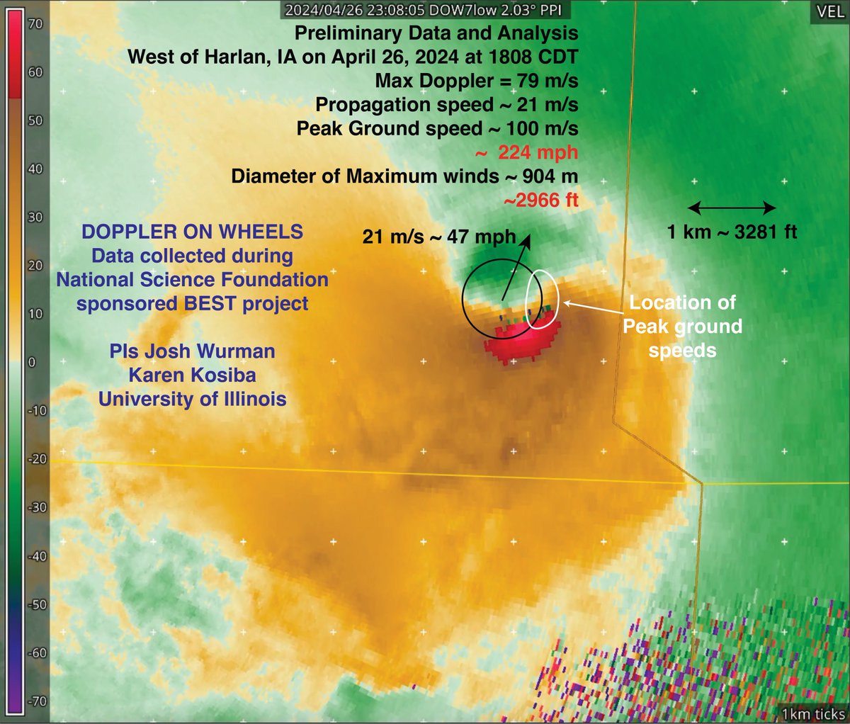
Preliminary Wind Summary Measurements and Analysis from Harlan, IA tornado on Friday (26 April 2024). Winds of ~224 mph and diameter of max winds of ~2966 ft. Observations were taken as part of the @NSF -sponsored #BEST project led by @karen_kosiba and @JoshuaWurman
account_circle
Rob Mayeda(@RobMayeda) 's Twitter Profile Photo

Blustery wrap up to the weekend… then some warmer temperatures, especially inland around midweek. Could see some shower chances returning next weekend…stay tuned. 4/27/2024

account_circle
NWS Hanford(@NWSHanford) 's Twitter Profile Photo

Our new Experimental Hiker Risk for the Pacific Crest Trail is up and running! This is just the beginning, new impacts will be added over the next month. Thank you to our collaborators! Pacific Crest Trail Association National Park Service National Weather Service Yosemite National Park Sequoia & Kings Cyn weather.gov/hnx/HikerRisk.…

account_circle