Savanna Lab(@SavannaLab_NMSU) 's Twitter Profile Photo

Are you excited about remote sensing of dryland vegetation? We are hiring postdoc positions to support our growing research efforts New Mexico State within the Jornada Basin LTER, NASA SERVIR Global, NASA GEDI, and ICESat-2 programs. See more details at savannalab.nmsu.edu/join-us/.
account_circle
Andy Shepherd(@AndyShep_CPOM) 's Twitter Profile Photo

A $300 million budget uplift is a fantastic opportunity for NASA Earth to kick start plans for new satellites. Would be great to see coordination with ESA Earth Observation and Copernicus EU to secure a legacy for essential missions like esa cryosat mission and ICESat-2 🤞

account_circle
Sérgio Godinho(@Godinho_ser) 's Twitter Profile Photo

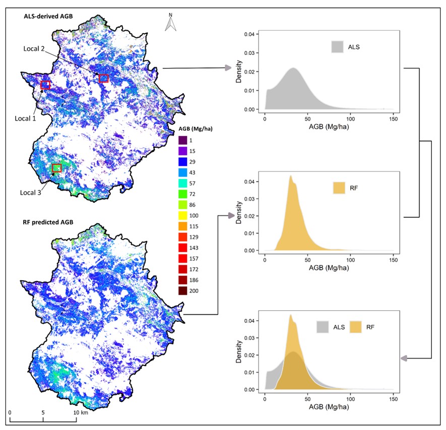
🚨 officially out! “Aboveground biomass mapping by integrating ICESat-2, SENTINEL-1, SENTINEL-2, ALOS2/PALSAR2, and topographic information in Mediterranean forests”. tandfonline.com/doi/full/10.10…. ICESat-2

🚨 officially out! “Aboveground biomass mapping by integrating ICESat-2, SENTINEL-1, SENTINEL-2, ALOS2/PALSAR2, and topographic information in Mediterranean forests”. tandfonline.com/doi/full/10.10…. @NASA_ICESat2
account_circle
Epoch Inspired(@EpochInspired) 's Twitter Profile Photo

“I have no idea why he ended up in Wales. Maybe the ice shifted while he was hunting.'🐶🧊🧊🧊

buff.ly/3Mciwn8

account_circle
Haiku, Inc.(@HaikuInc_) 's Twitter Profile Photo

Limited time only - click for a free demo!

Imagine if a video game could change your entire career - and your life. Welcome to World of Haiku. This is the answer you've been looking for.

account_circle
Helen Amanda Fricker ❄️❄️ ❄️(@helenafricker) 's Twitter Profile Photo

“We can make up for lost time and get on with it.”

NASA reboots its role in fighting climate change
nature.com/articles/d4158…

account_circle
Txomin Hermosilla(@txominhermos) 's Twitter Profile Photo

🚨📢New paper & new 30-m annual dataset❗️ We have improved our -based classification protocol with refined calibration data using airborne & , integrated novel predictors & spatially optimized implementation
sciencedirect.com/science/articl…

account_circle
Jonathan Amos(@BBCAmos) 's Twitter Profile Photo

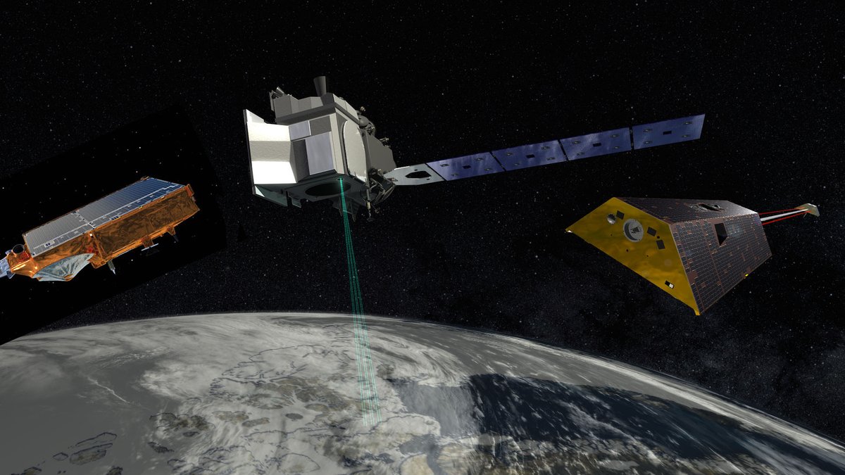
.esa cryosat mission will begin lifting its orbit on 16 July - only by just under 1km, but sufficient to bring it into a resonant orbit with ICESat-2 such that they each see the same piece of polar ice every 1.5 days at almost exactly the same time.

.@esa_cryosat will begin lifting its orbit on 16 July - only by just under 1km, but sufficient to bring it into a resonant orbit with @NASA_ICESat2 such that they each see the same piece of polar ice every 1.5 days at almost exactly the same time.
account_circle
Fabrice Ardhuin(@FabriceArdhuin) 's Twitter Profile Photo

What started as a game with OceanDataLab is now a paper: we looked for wind-wave patterns in ice-covered oceans in 5 different sensors: ICESat-2 ESA Earth Observation Sentinels 1,2 & 3 and . Preprint : researchgate.net/publication/35…
Picture shows ICESat-2 ice elevation over a S2 image
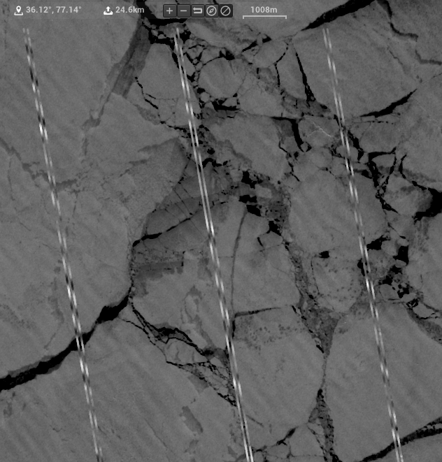
What started as a game with @oceandatalab is now a paper: we looked for wind-wave patterns in ice-covered oceans in 5 different sensors: @NASA_ICESat2 @ESA_EO Sentinels 1,2 & 3  and #CFOSAT.  Preprint : researchgate.net/publication/35…
Picture shows ICESat-2 ice elevation over a S2 image
account_circle
Bert Wouters(@bert_polar) 's Twitter Profile Photo

Want to join this stellar team? We're looking for a PhD student to come work with us at TU Delft Civil Engineering and Geosciences on combining ICESat-2, esa cryosat mission and data to better understand what's going on with our ice sheets

‼️ 4 days left to apply‼️
academictransfer.com/nl/299734/phd-…

Want to join this stellar team?  We're looking for a PhD student to come work with us at @TUDelft_CT on combining @NASA_ICESat2, @esa_cryosat and #GRACE data to better understand what's going on with our ice sheets

‼️ 4 days left to apply‼️
academictransfer.com/nl/299734/phd-…

#jobalert
account_circle
Josh King(@geomatics) 's Twitter Profile Photo

Early morning on our way to Resolute.

After a 10-day isolation we’ll move further North to Eureka.

We’ll be working on ICESat-2 and esa cryosat mission validation campaigns to improve sea ice products within the archipelago!

Early morning on our way to Resolute.

After a 10-day isolation we’ll move further North to Eureka.

We’ll be working on @NASA_ICESat2 and @esa_cryosat validation campaigns to improve sea ice products within the archipelago!
account_circle
Sarah Cooley(@sarahwcooley) 's Twitter Profile Photo

Out today in @nature: We use ICESat-2 data to quantify global variability in surface water storage and find that human-managed reservoirs account for 57% of all seasonal surface storage variability.

nature.com/articles/s4158…

account_circle
Deo(@deotectonics) 's Twitter Profile Photo

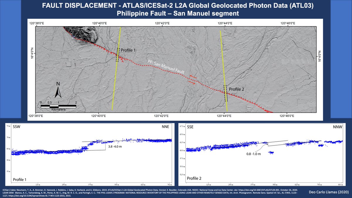
Measurement of fault vertical displacement along the Philippine Fault using / ATLAS data from National Snow and Ice Data Center. Alternative way if you don't have local LiDAR data. Probably, the first in the Philippines.

Measurement of fault vertical displacement along the Philippine Fault using #ICESat2 / ATLAS data from @NSIDC. Alternative way if you don't have local LiDAR data. Probably, the first in the Philippines.
account_circle
Camile Söthe(@SotheCamile) 's Twitter Profile Photo

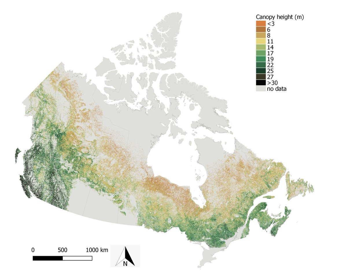
🚨Can be used to map forest canopy height in ?
In our newest publication, we compared the spaceborne and associated with , and to produce canopy height maps in forested ecosystems of Canada
mdpi.com/2072-4292/14/2…

🚨Can #GEDI be used to map forest canopy height in #Canada? 
In our newest publication, we compared the spaceborne #lidar #GEDI and #ICESat2 associated with #Sentinel1, #Sentinel2 and #PALSAR2 to produce canopy height maps in forested ecosystems of Canada
mdpi.com/2072-4292/14/2…
account_circle
Dr. Lola Fatoyinbo(@EarthToLola) 's Twitter Profile Photo

Today Nathan Thomas aka Nathan Thomas @[email protected] presented our work on shallow coastal bathymetry mapping with ICESat-2 and NASA Landsat Program at , including his C-Shelph software. Fully spaceborne bathymetry at 30 m resolution is within reach!
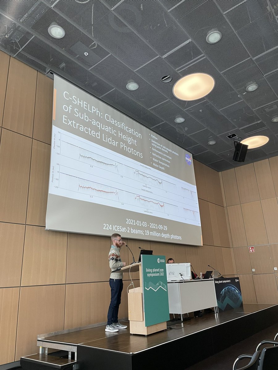
Today Nathan Thomas aka @DrNASApants presented our work on shallow coastal bathymetry mapping with @NASA_ICESat2 and @NASA_Landsat at #LivingPlanetSymposium , including his C-Shelph software. Fully spaceborne bathymetry at 30 m resolution is within reach!
account_circle
Dr. Lola Fatoyinbo(@EarthToLola) 's Twitter Profile Photo

I gave my first (public) hyperwall talk today 😊 on 3-D remote sensing of Coastal Ecosystems from , and . Always a pleasure to show all the work coming out of our and Land and team. ICESat-2 GEDI NASA CMS

account_circle